Imagine Berlin, a vibrant, sprawling metropolis. Now, picture it bisected, not by a river or a railway, but by a monstrous concrete barrier, studded with watchtowers and patrolled by armed guards. For 28 years, this was the stark reality of the Berlin Wall. Understanding the Berlin Wall map location isn’t just about pinpointing a spot on a modern city plan; it’s about tracing the physical scar that defined a generation and the ideological fault line of the Cold War.
This guide isn’t just a history lesson; it’s your blueprint for exploring the enduring presence of the Wall today, helping you navigate its significant remnants and memorial sites with confidence.
At a Glance: Tracing the Wall’s Legacy
- When was it built? August 12-13, 1961.
- When did it fall? November 9, 1989.
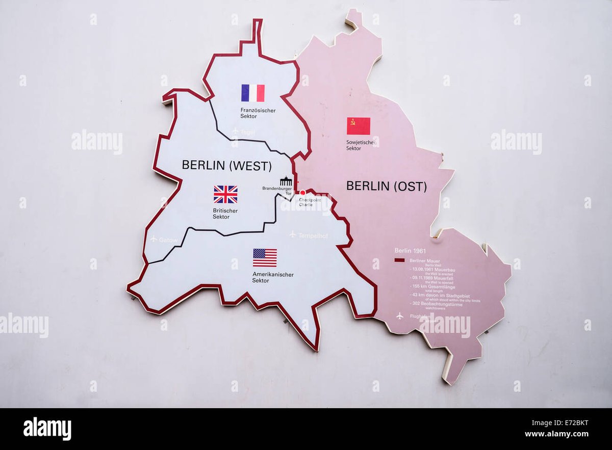
- How long was it? Approximately 155 kilometers (96 miles) around West Berlin.
- Its purpose? To prevent East Germans from escaping to West Germany.
- Key remnants today: East Side Gallery, Berlin Wall Memorial on Bernauer Strasse, Checkpoint Charlie.
- How to explore: Walk, cycle, use public transport, or join a guided tour along the Berlin Wall Trail.
The Iron Curtain’s Heartbeat: Where the Wall Once Stood
The Berlin Wall wasn’t merely a line on a map; it was an intricate, militarized system that completely encircled West Berlin, an island of democracy deep within communist East Germany (GDR). From the initial barbed wire fences hastily erected overnight to the formidable “Anti-Fascist Protection Rampart” it became, its location carved a permanent division through the city’s very soul. It cut through streets, isolated neighborhoods, and severed families without warning.
When you Explore the Berlin Wall map today, you’ll see a unified city, but the ghost of the Wall still subtly influences its urban planning and the locations of its most profound historical sites. Its route was dictated by the existing administrative borders of the four post-WWII occupation sectors – British, French, American (West Berlin), and Soviet (East Berlin). This meant the Wall snaked through residential areas, across waterways, and past major landmarks, creating an entirely artificial frontier.
More Than Just a Wall: The “Death Strip” Defined
To truly grasp the Berlin Wall’s map location, you need to visualize its complete structure. It wasn’t a single barrier, but a fortified corridor known as the “death strip.” At its peak, this system included:
- Two parallel concrete walls: Roughly 3.6 meters (12 feet) high, reinforced and topped with smooth pipes to make scaling difficult.
- A “death strip”: A wide, cleared area between the two walls, often filled with anti-vehicle trenches, tripwires, landmines (initially), and constantly raked sand or gravel to show footprints.
- Watchtowers: Over 300 strategically placed towers, housing armed guards with orders to shoot escapees.
- Floodlights: Illuminating the death strip for clear visibility, day and night.
- Guard dogs: Hundreds of trained dogs patrolled specific sections.
- Barbed wire and metallic fences: Preceding the main walls in many areas.
This entire apparatus stretched for 155 kilometers, making any attempt to cross a perilous gamble. When you Explore the Berlin Wall map, remember that this entire length was a zone of extreme danger, a chilling testament to the lengths a state would go to imprison its own people.
Finding the Wall Today: Tracing Its Imprint
While much of the physical Wall was torn down in the euphoric aftermath of November 1989, its presence is far from forgotten. The city has deliberately preserved significant segments and marked its former route, allowing visitors to comprehend its scale and impact. You can literally walk, cycle, or take public transport along its former path and discover the powerful stories embedded in these locations. Understanding the former Berlin Wall city map is crucial for appreciating its historical footprint.
Major Sites and Their Map Significance
Exploring the major sites gives you a tangible sense of the Wall’s exact location and its profound historical weight. Each offers a unique perspective on a city once brutally divided.
1. East Side Gallery: Art and Freedom Along the Spree
- Location: Mühlenstraße, Friedrichshain-Kreuzberg, along the Spree River.
- Map Relevance: This 1.3-kilometer section is the longest continuous remnant of the Wall. It formed part of the inner wall that separated East Berlin from the Spree River, which itself served as a border in many places.
- What you’ll see: Over 100 murals painted directly onto the concrete by international artists, transforming the former barrier of oppression into a vibrant open-air gallery celebrating freedom and hope. It’s a powerful visual reminder of the Wall’s dimensions and its transformation.
2. Berlin Wall Memorial (Gedenkstätte Berliner Mauer): The Most Authentic Insight
- Location: Bernauer Strasse, spanning across the former border between Wedding (West) and Mitte (East).
- Map Relevance: This is arguably the most important site for understanding the Wall’s full complexity. It preserves a 220-meter section of the original border fortifications, including both inner and outer walls, a watchtower, and the infamous “death strip.”
- What you’ll see: The open-air exhibition details the Wall’s construction, function, and fall, highlighting personal stories of escape and tragedy. The observation tower offers a chilling view into a reconstructed “death strip,” demonstrating exactly how the barrier functioned. The documentation center provides invaluable historical context, while the Chapel of Reconciliation stands on the former no-man’s land, a place of remembrance. When you visit this Explore the Berlin Wall site, you’ll gain a profound appreciation for its historical reality.
3. Checkpoint Charlie: The Iconic Cold War Crossing
- Location: Corner of Friedrichstrasse and Zimmerstrasse, between Mitte (East) and Kreuzberg (West).
- Map Relevance: This was the most famous border crossing point for foreigners, Allied personnel, and diplomats between East and West Berlin. Its location was strategically vital, a flashpoint for Cold War tensions.
- What you’ll see: A replica guardhouse marks the spot, surrounded by informational panels detailing its history, famous confrontations (like the 1961 tank standoff), and daring escape attempts. Nearby museums, though independently run, offer further context on escapes and espionage. The Explore the divided Berlin map will clearly show Checkpoint Charlie as a crucial crossing point.
4. Potsdamer Platz: From No-Man’s Land to Modern Marvel
- Location: Historically situated at the intersection of various districts (Mitte, Tiergarten), once a bustling square before WWII.
- Map Relevance: Post-WWII, this once-vibrant public square became a desolate wasteland directly on the border between the American, British, and Soviet sectors. It was part of the heavily fortified “death strip.”
- What you’ll see: Today, Potsdamer Platz is a shining example of modern Berlin, a testament to reunification. Amidst the towering skyscrapers, you’ll find subtle historical markers, including a few preserved Wall fragments and plaques explaining its past. It’s a striking contrast between past desolation and present vibrancy.
5. Friedrichstrasse Station: “Palace of Tears”
- Location: North of Unter den Linden, central Berlin.
- Map Relevance: This major train station served as a critical border crossing for both East and West Germans, as well as international travelers. Its unique architecture allowed for strict separation of passengers.
- What you’ll see: The station is still operational, but the former departure hall for West Berliners is now a museum called the “Palace of Tears” (Tränenpalast). It’s a poignant exhibition detailing the emotional goodbyes and strict border controls endured by those crossing in either direction.
6. Glienicke Bridge: The “Bridge of Spies”
- Location: Connecting Berlin (Wannsee district) with Potsdam, spanning the Havel River.
- Map Relevance: While not on the main Berlin Wall circuit around West Berlin, this bridge became an extension of the Cold War division, famous for its role in prisoner exchanges between the superpowers.
- What you’ll see: A functional bridge today, its history is marked by informational panels. Its isolated, almost cinematic location underlines the cloak-and-dagger atmosphere of Cold War espionage, earning it the moniker “Bridge of Spies.”
How to Navigate the Wall’s Former Footprint
Exploring the Berlin Wall map location comprehensively requires a good strategy, especially given its extensive length. You don’t need a physical map in hand; your smartphone is your best companion.
The Berlin Wall Trail (Berliner Mauerweg)
For the most immersive experience, consider the Berlin Wall Trail. This roughly 160-kilometer (99-mile) path traces the entire former border fortifications around West Berlin. It’s perfectly suited for cycling or walking, offering unique perspectives on the urban and suburban landscapes the Wall divided. Along the way, you’ll find:
- Historical markers: Explaining the significance of specific locations, escape attempts, or daily life under division.
- Preserved sections: Small, often unexpected fragments of the Wall that Remains of the Berlin Wall still stand.
- “Mauerstücke” (Wall pieces): Artistic installations or simple plaques that denote where the Wall once ran, especially in areas where no physical structure remains.
You can tackle the trail in segments, focusing on areas with higher concentrations of historical sites, like the central districts.
Public Transport: Your Best Ally
Berlin’s excellent public transportation network (U-Bahn, S-Bahn, trams, buses) makes navigating the Wall’s former route incredibly easy.
- U-Bahn/S-Bahn: Many stations are located near key sites. For example, Bernauer Strasse has its own U-Bahn station, and Friedrichstrasse Station is a major transport hub.
- Trams: Useful for reaching parts of the East Side Gallery.
- Buses: Can take you directly to some of the less central memorial sites.
Plan your route using Google Maps or Berlin’s public transport app (BVG Fahrinfo) to optimize your time.
Guided Tours vs. Self-Guided Exploration
- Guided Tours: If you prefer expert commentary, a guided tour is highly recommended. Many tours focus on specific aspects (e.g., escape stories, Cold War espionage, art of the East Side Gallery) and provide invaluable context you might miss on your own. They often use bikes or walking to cover significant ground.
- Self-Guided: For those who enjoy exploring at their own pace, a self-guided tour using a good map app (like Google Maps with pinned locations) and pre-downloaded audio guides or historical information can be very rewarding. Look for specific apps or websites dedicated to the Berlin Wall’s history for detailed route suggestions. You can also Explore Berlin Wall city map digitally on your phone for easy navigation.
Beyond the Concrete: The Human Stories and Enduring Legacy
The Berlin Wall’s map location isn’t just about geography; it’s about the countless human stories that unfolded within its shadow. From audacious escape attempts through tunnels (like Tunnel 57, which saw 57 people escape in 1964) and homemade hot-air balloons (the 1979 Strelzyk/Wetzel escape) to the tragic deaths of those shot while trying to cross, the Wall was a stage for both desperation and incredible bravery.
These stories highlight the profound impact of political division on daily life. Families were separated, relationships were strained, and basic freedoms were denied. The Wall was a daily reminder of ideological conflict, making it a tangible symbol of the Cold War.
The Wall Nowadays: A Symbol of Unity and Remembrance
Today, the spirit of remembrance is strong. The city and its citizens are committed to ensuring that the lessons of the Wall are never forgotten. The Berlin Wall now stands as a powerful educational tool, teaching future generations about totalitarianism, resilience, and the triumph of freedom. The preserved segments, memorials, and the Berlin Wall Trail serve as poignant reminders of a dark chapter, while also celebrating the reunification of Germany and Europe.
Common Questions About the Berlin Wall’s Location
Understanding the specific nuances of the Berlin Wall’s location often sparks a few common questions. Let’s tackle them head-on.
Did the Berlin Wall go all the way around Berlin?
Yes, but specifically, it went all the way around West Berlin. West Berlin was an enclave, entirely surrounded by East Germany (GDR) territory. The Wall effectively cut West Berlin off from East Berlin and the surrounding GDR countryside. It was a complete physical barrier enclosing West Berlin.
How much of the Berlin Wall is still standing today?
While the vast majority of the Wall was dismantled after 1989, significant and identifiable sections remain. The largest continuous segment is the 1.3 km East Side Gallery. The Berlin Wall Memorial on Bernauer Strasse preserves a substantial portion of the original border fortifications, including both walls and the death strip. Smaller fragments, historical markers, and the paved Berlin Wall Trail (Mauerweg) also indicate its former route throughout the city. While The Berlin Wall today is largely gone, its impact is undeniable.
Was the Berlin Wall located in East or West Berlin?
The Berlin Wall was technically located entirely on East German territory. The border was designed so that the Wall stood a few meters inside East German territory. This meant that the West Germans could not directly interfere with its construction or maintenance without entering East German sovereign land. The “death strip” and the inner wall were within East German control, with the outer wall facing West Berlin.
How far was the Berlin Wall from the Brandenburg Gate?
The Brandenburg Gate itself was a mere stone’s throw from the Berlin Wall, situated right on the border between East and West Berlin. For decades, the Brandenburg Gate stood directly in the “death strip,” inaccessible to both East and West Berliners, becoming a potent symbol of division. It was only after the Wall fell that people could freely pass through it again.
Your Journey Through History
Exploring the Berlin Wall map location is more than just a historical excursion; it’s an immersive journey into a pivotal moment in 20th-century history. From the vibrant murals of the East Side Gallery to the solemn reconstructed “death strip” at Bernauer Strasse, each site offers a unique lens through which to understand the Cold War, the struggle for freedom, and the eventual triumph of unity.
Whether you cycle the entire Wall Trail, hop between key monuments by public transport, or join a guided tour, allow yourself to reflect on the stories these locations tell. They are a powerful reminder of how quickly political lines can divide, and how resilient the human spirit can be in the face of oppression. Take the time to truly feel the history beneath your feet, and you’ll leave Berlin with a profound understanding of this extraordinary chapter in global history.


