The Berlin Wall sliced through Berlin, carving a scar into its very heart for nearly three decades. Today, a berlin wall city map is your indispensable guide, not just to finding remnants of concrete, but to tracing the invisible lines of history that still shape the German capital. It’s how you connect the city’s vibrant present with its profoundly divided past, revealing how a political barrier fundamentally altered lives, architecture, and even the city’s spirit.
At a glance
- Uncover the Wall’s hidden geography: Learn how to read a map not just for current streets, but for the invisible route of the former Wall and its impact.
- Identify key historical sites: Pinpoint major memorials, preserved segments, and significant former border crossings like Checkpoint Charlie and the Berlin Wall Memorial.
- Plan your self-guided exploration: Get practical advice on mapping out routes, utilizing public transport, and making the most of your time.
- Understand the Wall’s complex structure: Grasp that the Wall was more than a single barrier, and how maps help visualize its layered defenses.
- Connect past and present: See how modern Berlin developed around and over its former divisions, visible through the lens of a historical map.
The Invisible Blueprint: Why Your Berlin Wall City Map Matters
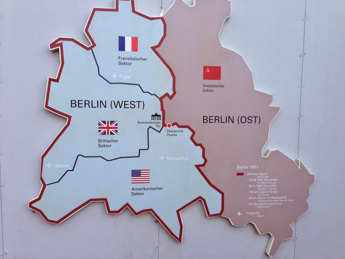
The Berlin Wall was more than just a barrier; it was a complex military system that fundamentally reshaped one of Europe’s largest cities. From the night of August 12-13, 1961, until its fall on November 9, 1989, it tore through neighborhoods, severed transport links, and isolated West Berlin from its surroundings. A berlin wall city map becomes a historical blueprint, allowing you to trace these profound changes, visualizing the exact route, its fortifications, and the human stories embedded within its former path.
Understanding the Wall’s true nature is key: it wasn’t just a single line. It comprised two parallel concrete walls, roughly 12 feet high, separated by a “death strip” filled with obstacles, watchtowers, and alarm systems. At its peak, this 155-kilometer (96-mile) system was patrolled by thousands of guards, making escape a deadly gamble. Your map helps you not just see where a wall stood, but where this entire complex system once dominated the urban landscape, from the center to the periphery of West Berlin.
Deciphering the Divide: How the Wall Reshaped Berlin’s Urban Fabric
The Wall’s sudden appearance fractured Berlin’s physical and social fabric overnight. Streets were abruptly cut in half, forcing residents on one side into stark isolation from those just meters away. For nearly three decades, families were separated, communities divided, and daily routines brutally rerouted. A berlin wall city map from that era would look dramatically different from one today, highlighting closed-off roads, blocked waterways, and the extensive military zones that replaced bustling public spaces.
Even today, these historical scars are visible if you know where to look. Modern infrastructure sometimes follows the Wall’s former path, or deliberately avoids it. You might notice unusual gaps between buildings, sudden changes in architectural styles from East to West, or streets that abruptly end and pick up again further down. Your map acts as a historical overlay, helping you see the phantom lines of division and understand how they continue to influence Berlin’s layout and character.
Navigating the Past: Core Sites to Mark on Your Berlin Wall City Map
While most of the Wall was demolished after 1989, significant traces and memorials remain, offering potent reminders of its legacy. A good berlin wall city map will highlight these key locations, allowing you to stitch together a comprehensive narrative of division and reunification. For a broader overview of the Wall’s historical route and context, our comprehensive Berlin Wall map guide offers further insights.
Here are the essential sites to mark and explore:
- East Side Gallery: This 1.3-kilometer stretch along the Spree River is the longest remaining segment of the Wall. Once a drab, guarded barrier, it’s now an open-air art gallery featuring over 100 murals by international artists, celebrating freedom and hope. Your map shows its impressive length, distinct from other, more fragmented sections.
- Berlin Wall Memorial (Bernauer Strasse): Located at a site where the division was particularly cruel—families jumping from windows to escape—this memorial preserves original wall sections, guard towers, and a full section of the “death strip.” It offers a profound, immersive experience with an excellent documentation center and visitor facilities. A map here helps orient you within the vast outdoor exhibition.
- Checkpoint Charlie: The most famous border crossing between East and West Berlin. While the original guardhouse is gone (a replica stands in its place), the site remains a powerful symbol of Cold War tensions. Museums nearby offer detailed accounts of daring escapes and confrontations. Your map will show its strategic location, once a focal point of international drama.
- Potsdamer Platz: Once a bustling European square, it became a desolate wasteland split by the Wall after 1961. Today, it’s a vibrant, modern hub. Your map can help you find the subtle historical markers and small, preserved fragments of the Wall that remind visitors of its previous, bleak existence.
- The Berlin Wall Trail (Berliner Mauerweg): For those wanting a deeper dive, this 160-kilometer path for walking and cycling follows the entire former course of the Wall around West Berlin. It integrates information panels and smaller memorials, offering an extensive journey through historical landscapes. A specialized berlin wall city map or a digital overlay is crucial for navigating its full length.
Beyond the Obvious: Uncovering Hidden Traces with Your Map
Beyond the major sites, a good berlin wall city map can guide you to more subtle, yet equally poignant, traces of the Wall’s existence. These are the details often overlooked by casual visitors, but they offer deeper insights into the everyday reality of a divided city.
- Cobblestone Lines: In many parts of central Berlin, the exact former path of the Wall is marked by a double line of cobblestones embedded in the street. These subtle markers appear in unexpected places, bisecting parks, pavements, and modern buildings. A detailed map helps you spot these lines, especially in areas like Brandenburg Gate or near Potsdamer Platz, where only fragments of the Wall remain.
- Ghost Stations (Geisterbahnhöfe): While not direct Wall remnants, these former subway and S-Bahn stations were sealed off in East Berlin but remained operational on West Berlin lines that passed underneath. Passengers on West Berlin trains would briefly glimpse dimly lit, heavily guarded platforms. Your map can show you the routes of these lines and where these “ghosts” once lay, like the former Nordbahnhof.
- Informational Steles and Plaques: Throughout the city, particularly along the Wall’s former route, you’ll find numerous steles (tall pillars) and small plaques. These often provide historical context for that specific location, detailing an escape attempt, a significant event, or simply showing a photograph of the Wall as it stood there. Your map can help you connect these localized stories to the broader narrative of the Wall.
- Architectural Anomalies: Keep an eye out for buildings that appear to have oddly truncated facades, or where a street abruptly changes character. In some cases, buildings that once backed onto the death strip had their windows bricked up or their rear entrances sealed. Your map, combined with keen observation, can help identify these architectural scars.
Crafting Your Self-Guided Tour: Practical Steps for Using a Berlin Wall City Map
Creating your own Berlin Wall exploration plan is both rewarding and highly personalized. Your berlin wall city map is your primary tool for this.
- Choosing the Right Map:
- Digital Maps (Google Maps, Apple Maps): Excellent for real-time navigation, public transport integration, and searching for specific addresses. Many tourism apps also offer downloadable offline maps with Wall markers. Look for layers that highlight the Wall’s former route.
- Physical Maps: Often available at tourist information centers, bookstores, or memorial sites. A good physical map provides a comprehensive overview without screen distractions. Some specialized maps explicitly highlight the Wall’s path and related sites.
- Specialized Wall Maps: Specific historical maps or apps designed for the Berlin Wall Trail offer the most detailed insights, often with historical photos and information alongside the modern layout.
- Planning Your Route & Grouping Sites:
- Thematic Grouping: Consider organizing your visit by theme. For example, dedicate a morning to the Berlin Wall Memorial (Bernauer Strasse) for its comprehensive historical overview. Then, in the afternoon, visit the East Side Gallery for its artistic interpretation and the feel of the riverfront.
- Geographic Proximity: Look at your map and group sites that are close to each other. For instance, Checkpoint Charlie, Topography of Terror (which also touches on Nazi history), and Potsdamer Platz are relatively close in the city center.
- Public Transport (U-Bahn/S-Bahn): Berlin’s public transport system is excellent. Mark U-Bahn (subway) and S-Bahn (city train) stations on your map near the sites you want to visit. For example, the East Side Gallery is near Ostbahnhof or Warschauer Strasse, while Bernauer Strasse is directly accessible by U8. A single day pass or multi-day pass is usually the most economical option.
- Time Management & Pacing:
- Allocate Sufficient Time: Don’t rush. The Berlin Wall Memorial alone can take 2-3 hours for a thorough visit. The East Side Gallery can be walked in 30-60 minutes, but you might want more time for photos and reflection.
- Breaks and Reflection: The history can be heavy. Plan for breaks at cafes, parks, or quiet spots along your route. Use your map to locate green spaces or amenities.
- Consider Half-Day vs. Full-Day Tours: For a focused experience, pick one or two major sites for a half-day. To see multiple key locations, plan a full day, perhaps combining two distinct geographic areas.
- What to Look For (and Mark on Your Map):
- Original Sections vs. Replicas: Note on your map whether a segment is original or a reconstruction (e.g., the Checkpoint Charlie guardhouse).
- Watchtowers: Identify remaining guard towers (e.g., at the Berlin Wall Memorial, or near Potsdamer Platz).
- Informational Panels: Keep an eye out for bilingual panels at key locations that provide photographs and historical context for that exact spot.
- Victim Memorials: Many small memorials commemorate those who died trying to cross. These are deeply personal and powerful.
Pitfalls to Avoid When Exploring the Wall’s Legacy
While a berlin wall city map empowers your exploration, be mindful of common pitfalls:
- Over-reliance on Tourist Traps: While Checkpoint Charlie is iconic, avoid spending all your time there. The area can be very commercialized. Use your map to explore nearby, more authentic sites like the Berlin Wall Memorial for a deeper historical dive.
- Underestimating the Emotional Weight: The history of the Wall is profoundly sad and impactful. Be prepared for the emotional resonance of sites like the Berlin Wall Memorial, where the human cost is palpable.
- Ignoring the Context: Simply looking at a piece of the Wall without understanding its historical context (why it was built, who suffered, how it fell) diminishes the experience. Use informational panels and museum visits to deepen your understanding.
- Trying to See Everything in One Day: The Wall’s route is vast, and its remaining traces are spread across the city. Attempting to visit every single spot in a short timeframe will lead to exhaustion and a superficial understanding. Prioritize a few key locations using your map.
- Not Fact-Checking Souvenirs: Many vendors sell “pieces of the Wall.” Be skeptical; most are not authentic. Focus on genuine educational experiences rather than physical mementos.
Quick Answers: Your Berlin Wall City Map FAQs
How much of the original Berlin Wall is left today?
Very little of the original 155-kilometer Wall remains. The longest continuous section is the 1.3-kilometer East Side Gallery. Other significant, preserved sections can be found at the Berlin Wall Memorial (Bernauer Strasse) and in various smaller fragments throughout the city, often marked by cobblestone lines on a berlin wall city map.
Can I walk or cycle the entire length of the Wall?
Yes, the Berlin Wall Trail (Berliner Mauerweg) allows you to walk or cycle the entire 160-kilometer former perimeter of West Berlin. It is well-marked with historical information, and specialized berlin wall city map resources are available for navigation. This is a multi-day endeavor for most.
Are there guided tours that use a specific map for the Wall sites?
Many guided walking and cycling tours in Berlin focus on the Wall. While they may not provide a specific map for you to keep, guides often use historical maps to illustrate their points, showing you how the city looked then compared to now. They can be excellent for getting historical context and pinpointing key areas.
What kind of map is best for exploring the Wall?
A detailed digital map (like Google Maps) with public transport overlays is highly practical for real-time navigation to individual sites. For a deeper historical understanding and to visualize the entire route, a dedicated historical berlin wall city map or an app specifically designed for the Berlin Wall Trail is invaluable. Combining both offers the best of both worlds.
Your Actionable Blueprint for Berlin Wall Exploration
Your journey through Berlin’s divided past begins with a simple decision: where to start, and what story you want to uncover. Arm yourself with a good berlin wall city map – whether digital or physical – and prioritize your experience.
- Start with Context: Begin at the Berlin Wall Memorial at Bernauer Strasse. It offers the most comprehensive and poignant insight into the Wall’s physical reality and human cost. Use your map to navigate the outdoor exhibition and the documentation center.
- Experience the Art: Transition to the East Side Gallery. While distinct in tone, it represents the hope and freedom that followed the Wall’s fall. Your map helps you appreciate its length along the Spree.
- Trace the Route: Between these major sites, use your map to follow the subtle cobblestone lines, look for informational steles, and identify former border crossings like Checkpoint Charlie. Don’t be afraid to veer off the main tourist paths to discover less-frequented segments or markers.
- Embrace Public Transport: Berlin’s U-Bahn and S-Bahn are your best friends. Mark relevant stations on your map to efficiently travel between disparate Wall sites.
- Reflect and Connect: Allow time for reflection at each site. Your berlin wall city map isn’t just about locations; it’s a tool for connecting with a pivotal chapter in human history and understanding the enduring impact of division on a vibrant metropolis.


