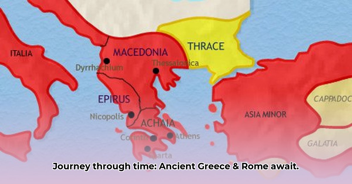
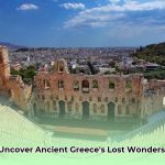
Ever wonder how people in ancient Greece and Rome pictured their world? It wasn’t like having Google Maps! Their maps were far from perfect, but they offer a surprisingly captivating glimpse into their lives and empires. This article takes you on a journey through the history of ancient mapmaking, exploring how these maps evolved, what they got right (and wrong!), and how historians still debate what they really mean. We’ll examine captivating examples, revealing the stories hidden within their lines and labels – and maybe even challenging some things you thought you knew about the past. For a visual representation of ancient Greece, check out this helpful map.
Mapping the Ancient World: A Journey Through Ancient Greek and Roman Cartography
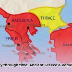
Imagine piecing together a puzzle of ancient Greece and Rome without a map. Nearly impossible! The maps from these periods weren’t the detailed, precise tools we use today. Instead, view them as historical sketches, reflecting the knowledge, technology, and prevailing worldview of the time. They paint a picture of how people perceived their world, not necessarily how it objectively appeared. These ancient cartographic representations are invaluable tools for understanding ancient trade networks, military campaigns, and the dissemination of geographical knowledge.
Charting the Course: The Dawn of Ancient Cartography and Geographic Thought
Early Greek mapmakers, like Anaximander and Hecataeus, relied heavily on accounts from sailors, merchants, and travelers. Their maps, often drawn on papyrus or etched onto clay tablets, primarily focused on representing important features like trade routes, coastal settlements, and territorial boundaries. Accuracy, in the modern sense, was not their foremost concern. The Romans, with their vast empire and practical administrative needs, developed more sophisticated mapping techniques, including land surveying (agrimensores) and road charting. However, even their efforts were constrained by the limitations of available surveying instruments, projection methods, and the sheer scale of their territorial holdings. Consider the difference in focus: the Greeks, driven by philosophical inquiry, aimed to understand the cosmos and humanity’s place within it, while the Romans prioritized practical applications for governance and military expansion.
A Closer Look at Surviving Ancient Maps: Fragments of a Lost World
Finding well-preserved examples of ancient Greek and Roman maps is challenging; many exist only as fragments, copies, or later reconstructions. However, even these remnants offer invaluable insights. Some demonstrate remarkable detail for their time, accurately depicting major cities, coastlines, and mountain ranges. Others are more schematic, emphasizing political relationships or trade connections over precise geographical representation. It is crucial to consider how maps from different eras relate to one another, tracing the evolution of cartographic techniques and geographical knowledge. For instance, a map from the time of Alexander the Great might emphasize the vast extent of his conquests, while a Roman road map focuses on the efficient movement of troops and goods across the empire. This difference reflects the distinct purposes and priorities driving mapmaking in each era.
Unraveling the Mysteries: Challenges and Debates in Interpreting Ancient World Maps
Interpreting ancient maps is a complex and multifaceted endeavor. Even relatively detailed maps contain inconsistencies, distortions, and ambiguities. Pinpointing precise borders, identifying ancient place names, and reconciling conflicting accounts pose persistent challenges. Furthermore, problems of scale, projection, and symbolization complicate comparisons between different maps and assessments of their overall accuracy. How did practical limitations, such as inaccurate surveying instruments or incomplete geographical knowledge, impact the reliability of these maps?
These challenges underscore the importance of understanding the historical and cultural context surrounding each map. Each map represents a snapshot of a particular time and place, reflecting not only geographical knowledge but also the mapmaker’s perspective, biases, and intended audience. The inherent difficulties that ancient cartographers faced offer a valuable glimpse into the intellectual and technological landscape of the ancient world.
Rediscovering the Past: New Technologies and Evolving Interpretations of Historical Cartography
Our understanding of ancient maps is constantly evolving, thanks to ongoing archaeological discoveries and advancements in digital technology. New finds, combined with sophisticated digital mapping techniques, allow us to re-examine old maps with fresh eyes, identify previously unnoticed features, and reconstruct damaged or incomplete maps. For example, Geographic Information Systems (GIS) enable researchers to overlay ancient maps onto modern satellite imagery, compare different maps from the same period, and analyze spatial relationships between settlements, trade routes, and geographical features. This continuous process of refinement ensures a dynamic and nuanced perspective on ancient cartography and its significance for understanding the ancient world.
Exploring the Archives: Resources for Studying Ancient Maps
Many online databases, digital archives, and museum collections offer high-quality images and detailed descriptions of ancient maps. Academic journals, scholarly monographs, and conference proceedings regularly publish cutting-edge research on ancient cartography. However, it is crucial to exercise critical judgment when using online resources; not all sources are equally reliable or accurate. Look for well-documented studies published by reputable academic institutions or museums. Keep in mind that even the most authoritative sources represent interpretations, not absolute truths. What criteria do historians use to evaluate the credibility of different sources when studying ancient maps?
The Enduring Legacy: Beyond Geography, A Window into the Ancient Mind
Despite their imperfections and limitations, ancient maps offer a priceless glimpse into the past. They are not merely static representations of geographical knowledge; they are dynamic reflections of human curiosity, ambition, and power. They provide visual narratives of political expansion, military campaigns, cultural exchange, and the complex interactions between different peoples in the ancient Mediterranean world. Ancient maps are essential tools for interpreting historical texts, understanding ancient spatial concepts, and reconstructing the lived experiences of people in the past. By acknowledging both their strengths and their weaknesses, we can gain a more complete and nuanced understanding of the ancient world and its enduring legacy.
A Summary of Map Types and Characteristics:
Map Type
Time Period
Characteristics
Strengths
Weaknesses
Greek Maritime Charts
Classical-Hellenistic Era
Primarily coastal, emphasizing ports, trade routes, and island locations
Depicts seafaring knowledge, trade connections, and coastal geography
Focus on political boundaries, territorial control, and power relationships
Highlights political dynamics, demonstrating control
Lack of geographical precision, potential for propaganda
Ptolemaic Maps
Roman Period/Late Antiquity
Systematic approach using mathematical principles, latitude/longitude grid
Advanced cartographic techniques, attempts at geographical accuracy
Subject to distortions, reliance on limited data, potential mathematical errors
The study of ancient maps continues to evolve as new discoveries are made and new analytical techniques are developed. This ongoing journey of exploration and discovery promises to further illuminate our understanding of the ancient world. What are the potential implications of a more accurate and comprehensive understanding of ancient cartography for studies of ancient civilizations and their interactions?
How to Verify Accuracy of Ancient World Maps Showing Roman Provincial Boundaries
Key Takeaways:
Roman maps prioritized practicality and administrative utility over perfect mathematical accuracy.
Their primary purpose was to facilitate governance, military operations, and resource management.
Surviving fragments offer valuable insights into Roman cartographic practices but are inherently incomplete.
Comparing ancient maps to modern geography presents numerous challenges due to changing landscapes and limitations of ancient surveying techniques.
Discrepancies between ancient maps and modern geographical data highlight the limitations of ancient technologies and the biases inherent in Roman mapping practices.
The Roman Approach to Cartography: Pragmatism Over Precision
Unlike the Greeks, who often pursued theoretical perfection in their mapmaking endeavors, the Romans prioritized practical applications. Their maps served crucial administrative and military functions, enabling them to manage their vast empire, track troop movements, and plan infrastructure projects. Accuracy, therefore, was defined relative to these specific needs. Road maps, for example, emphasized the efficient movement of goods and soldiers, while cadastral surveys focused on property boundaries and tax collection. What specific innovations allowed for the mass production and dissemination of road maps for the Roman army and administration?
Analyzing the Evidence: What We Know and What We Don’t
Numerous challenges impede our ability to definitively verify the accuracy of ancient Roman maps. The available evidence is often fragmented, incomplete, and subject to interpretation. Think of assembling a complex jigsaw puzzle with many missing pieces and ambiguous images. Furthermore, ancient mapmakers employed a variety of materials, including papyrus, parchment, and painted walls, each with varying degrees of durability and resistance to decay. The uneven survival rate of these materials results in a biased sample of evidence, with more fragments surviving from certain regions or time periods than others. These surviving map fragments represent invaluable but incomplete evidence, requiring expert analysis and careful contextualization.
The Tabula Peutingeriana, a well-known and widely studied example, is a remarkable road map of the Roman Empire, but its distortions and simplifications are readily apparent. The map compresses distances, exaggerates the importance of certain cities, and omits numerous geographical features. Scholars continue to debate the extent to which the Tabula Peutingeriana accurately reflects actual distances and locations, or whether it served primarily as a symbolic representation of Roman power and control.
We know that Roman surveyors used instruments such as the groma (a surveying tool) and the odometer to measure distances on land, but the accuracy of these measurements was undoubtedly affected by terrain, weather conditions, and human error. Sea routes were even more challenging to represent accurately, relying on sailors’ estimations, dead reckoning, and anecdotal reports. The limitations of Roman-era tools and techniques had a significant impact on maritime navigation and data collection, resulting in frequent inaccuracies and distortions in coastal representations.
How to Verify Accuracy of Ancient World Maps Showing Roman Provincial Boundaries: A Multifaceted Approach
Verifying the accuracy of these maps requires a multi-pronged approach:
Cross-referencing: Compare the map’s information with other ancient sources – literary texts, inscriptions, archaeological evidence, and administrative records. This helps to contextualize the map, identify potential errors, and corroborate or contradict its depictions.
Geographical Analysis: Analyze the locations depicted on the map in relation to modern geographical data, considering changes in coastlines, river courses, and land use patterns over time. Modern geographical knowledge provides a valuable comparative framework for assessing the accuracy of ancient maps, but it is crucial to account for environmental changes and tectonic shifts that have occurred since antiquity.
Technological Limitations: Acknowledge the technological constraints of Roman-era mapmakers. They lacked advanced surveying instruments, precise timekeeping devices, and sophisticated projection techniques. Understanding these limitations is crucial for interpreting the maps fairly and avoiding anachronistic expectations.
Purpose and Bias: Consider the map’s purpose and any biases it might reflect. Military maps, for example, might prioritize strategic locations and exaggerate the size of fortifications, while administrative maps may emphasize areas with high population density or tax revenue. Recognizing these biases is essential for interpreting the map’s representation of provincial boundaries and geographical features.
Collaboration: Engage with other experts – historians, geographers, archaeologists, and GIS specialists – to build a more comprehensive understanding of the map and its historical context. A collaborative, interdisciplinary approach is essential, as these maps are notoriously complex and require expertise in multiple fields.
The Ongoing Debate: Uncertainties and Interpretations
Despite our best efforts, significant uncertainties remain regarding the accuracy and interpretation of ancient Roman maps. The precision of longitudinal measurements is particularly debated, as the Romans lacked a reliable method for determining longitude at sea. This challenge is compounded by the subjectivity inherent in interpreting ancient sources and the potential for modern biases to influence our understanding of Roman cartographic practices.
These ongoing debates highlight the need for critical engagement with ancient Roman maps and a nuanced appreciation of their limitations. These ancient creations, while imperfect, are invaluable windows into the Roman mind, its administrative practices, and its understanding of the world. Continued research, interdisciplinary collaboration, and technological innovation are essential for furthering our understanding of Roman cartography and its significance for the study of ancient history. Further research and preservation may be conducted to save the remaining history.
Comparative Analysis of Roman and Greek Cartographic Techniques and Their Evolution
Key Takeaways:
Greco-Roman cartography evolved from basic representations of geographical space to sophisticated tools reflecting both practical needs and symbolic aspirations.
Limited physical evidence forces scholars to rely heavily on literary sources, fragmented maps, and indirect evidence.
A Comparative Analysis of Roman and Greek Cartographic Techniques and Their Evolution reveals significant differences in style, accuracy, purpose, and underlying philosophical assumptions.
Interpreting ancient maps requires careful consideration of their historical context, intended audience, and the limitations of ancient technology.
Modern scholarship emphasizes the cultural, intellectual, and political significance of ancient maps, viewing them as complex artifacts that shaped and reflected ancient worldviews.
Mapping the Ancient World: A Tale of Two Civilizations
What did ancient maps really look like? Were they geographically accurate representations of the world? Or were they more about power, symbolism, and storytelling than precise location? The answers are complex and nuanced, particularly when comparing the cartographic approaches of the Greeks and Romans. Both civilizations left behind fascinating, albeit fragmented, evidence, forcing us to piece together a comprehensive picture from literary descriptions, surviving fragments, and educated guesses based on archaeological and historical data.
A Comparative Analysis of Roman and Greek Cartographic Techniques and Their Evolution reveals key differences in their respective approaches to mapmaking. While the Greeks, with their emphasis on philosophical inquiry and empirical observation, tended toward geographically-oriented maps that sought to represent the cosmos and humanity’s place within it (think of Eratosthenes’ attempts to calculate the circumference of the Earth), the Romans prioritized pragmatic concerns related to governance, military expansion, and resource management. Roman maps, more often than not, were practical tools designed to facilitate the administration and control of their vast empire. They helped to manage their vast empire.
The Greek Approach: Philosophy Meets Geography
Greek mapmaking was not simply about plotting locations; it reflected their philosophical understanding of the cosmos and their place within it. Early Greek maps were often simple sketches, reflecting the limited geographical knowledge of the time and relying heavily on mythological and poetic descriptions of the world (such as those found in Homer’s Iliad and Odyssey). But as their world expanded through exploration, colonization, and increased interaction with other cultures, so too did their cartographic ambitions. Philosophers like Anaximander and Hecataeus attempted to create more comprehensive and geographically accurate maps of the known world, incorporating information from travelers’ accounts and astronomical observations. These maps were not perfectly accurate by modern standards, but they demonstrate a growing understanding of geography and a desire to represent the Earth as a coherent and measurable entity.
The Roman Legacy: Practicality and Power
Roman cartography was primarily driven by the practical needs of a massive empire. As Roman power expanded across the Mediterranean and beyond, their maps became increasingly important for military campaigns, trade routes, and administrative purposes. This led them to develop sophisticated mapmaking techniques, including the use of standardized scales, projection methods, and road surveying techniques. The Peutinger Table (Tabula Peutingeriana), a remarkable surviving example, demonstrates the meticulous charting of Roman roads, settlements, and geographical features across their sprawling empire.
However, Roman maps also served broader political and ideological purposes. They were not just utilitarian tools; they were instruments of power, demonstrating the extent of Roman authority and reinforcing imperial ideology. The Forma Urbis Romae, a large-scale marble map of the city of Rome created during the reign of Emperor Septimius Severus, stands as a powerful testament to Roman urban planning, engineering prowess, and imperial grandeur. It wasn’t merely a map; it was a statement of Roman power and civilization. This map demonstrates the empire’s sophistication and ability to develop and maintain detailed maps for urban design and administrative purposes.
Challenges of Interpretation
Reconstructing a complete and accurate picture of Greco-Roman cartography poses significant challenges for modern scholars. The scarcity of surviving physical maps, combined with the fragmentary nature of the available evidence, leaves researchers relying heavily on literary sources, many of which are themselves incomplete, biased, or open to various interpretations. Ancient authors often had different goals in mind when describing maps or geographical features, sometimes prioritizing dramatic effect, rhetorical persuasion, or allegorical meaning over strict geographical accuracy.
Determining the actual level of geographical accuracy in ancient maps is a difficult and often subjective exercise, requiring careful consideration of the limitations of ancient technology, the purpose for which the map was created, and the cultural context in which it was produced. This Comparative Analysis of Roman and Greek Cartographic Techniques and Their Evolution underscores the importance of recognizing that ancient maps were not simply objective representations of geographical reality, but rather complex cultural artifacts that were shaped by the knowledge, beliefs, and biases of their creators. How has modern technology helped scholars overcome the challenges of interpreting ancient maps and literary sources?
A Lasting Impact
Despite the challenges and limitations, studying Greco-Roman cartography offers invaluable insights into the intellectual, cultural, and political landscape of antiquity. These maps serve as a reminder that cartography has always been as much about interpretation, imagination, and the construction of meaning as it is about precise measurement and objective representation. These ancient maps serve as a reminder that cartography has always been as much about interpretation and imagination as it is about precise location.
Utilizing Ancient Maps for Understanding Geopolitical Dynamics in the Mediterranean
Key Takeaways:
Ancient maps offer invaluable insights into the geopolitical landscape of the Mediterranean world, despite their inherent limitations and inaccuracies.
Mapmaking techniques evolved significantly over time, reflecting advances in geographical knowledge, mathematical understanding, and surveying technology.
Interpreting these maps requires careful consideration of the creators’ biases, the intended audience, and the practical challenges of ancient cartography.
Digital resources and analytical tools have revolutionized access to and study of these historical artifacts, enabling new forms of analysis and interpretation.
Utilizing Ancient Maps for Understanding Geopolitical Dynamics in the Mediterranean requires a multidisciplinary approach, integrating historical, archaeological, art historical, and geographical expertise to reconstruct the complex interplay of power, trade, and cultural exchange in the ancient world.
Charting a Course Through Time: The Evolution of Mediterranean Cartography
Imagine trying to understand modern global politics without access to maps. The same holds true for the ancient Mediterranean world. Ancient maps, though often imperfect and incomplete by modern standards, are our windows into the past, revealing the shifting power dynamics, evolving trade routes, and complex cultural interactions that shaped the region. The more we are able to understand that period, the better we can develop our own perceptions of the world.
Early attempts at mapping were rudimentary sketches, representing coastlines, major cities, and prominent landmarks. As societies developed, their cartographic skills advanced, leading to more sophisticated and geographically accurate representations of the Mediterranean world. The Romans, with their vast empire and practical administrative needs, further refined mapping techniques to support military campaigns, facilitate administrative control, and ensure efficient trade networks.
From Papyrus to Pixels: Accessing Ancient Cartographic Treasures
The digital age has transformed our access to these invaluable historical resources. Online databases, museum collections, and academic archives allow us to examine ancient maps with unprecedented ease and detail. High-resolution digital images, interactive mapping platforms, and sophisticated search tools have revolutionized the study of ancient cartography, enabling scholars to analyze maps in ways that were previously impossible. However, the quality of digital reproductions varies greatly, and not all maps have been digitized, creating frustrating gaps in our knowledge and hindering comprehensive analysis. How can we ensure that digital archives adequately represent and preserve historical cartographic information for future generations?
Deciphering the Past: Challenges in Interpretation
Interpreting ancient maps is far from straightforward. Many were created for specific purposes, such as military strategy, trade promotion, or political propaganda. Ancient geopolitics were complex, and interpreting these documents requires a significant amount of research. This means that certain areas might be emphasized while others are minimized, reflecting the power structures, biases, and ideological agendas of the era. Furthermore, inconsistencies in place names, geographical features, and measurement scales can hinder accurate identification and comparison across different maps and time periods. In order to increase the accuracy, how do we reconcile differing versions of the same location or feature across multiple ancient maps and literary sources?
The Geopolitical Puzzle: Maps and Mediterranean Power
Utilizing Ancient Maps for Understanding Geopolitical Dynamics in the Mediterranean requires understanding their relationship to the broader political landscape. Ancient maps reveal the ebb and flow of power across the region. For example, we can trace the expansion of the Roman Empire by observing the gradual incorporation of new territories and the strategic positioning of military fortifications on successive maps. These ancient maps can tell a wealth of information related to ancient territories. How did geographical conditions, such as access to natural resources, strategic waterways, or defensible terrain, create economic or military advantages for particular groups in the ancient Mediterranean world?
A Digital Future for Ancient Maps?
The future of studying ancient maps lies in the continued digitization of existing collections, the development of improved search tools, and the creation of interactive digital platforms that facilitate collaborative research and public engagement. Consistent metadata standards, advanced data analysis techniques (such as spatial statistics and network analysis), and interdisciplinary collaboration are needed to unlock the full potential of these resources for understanding the complex geopolitical dynamics of the ancient Mediterranean world. In what ways might future studies incorporate artificial intelligence (AI) and machine learning to improve the interpretation of fragmented texts, identify patterns in geographical data, and reconstruct lost or damaged maps?
Hello, My love for writing is rivaled only by my passion for in-depth research. While many may skim the surface, I dive deep, seeking the hidden gems of information that give a story texture and depth. Every word I write is backed by hours of exploration, ensuring that my work is not just compelling, but also meticulously accurate. Join me on a journey where every piece is a deep dive into the realms of knowledge and storytelling.