The immensity and intricacy of Roman history can often feel like an overwhelming labyrinth, akin to navigating an ancient city without a compass or guide. Yet, imagine possessing not merely a static image, but a dynamic, interactive gateway—a labeled ancient Rome map—that serves as your ultimate key to unlocking the empire’s profound secrets. See a useful example of a labeled Rome map. This article will demonstrate precisely how these sophisticated cartographic tools illuminate Rome’s remarkable genesis, its monumental expansion across continents, the nuanced complexities of its vital regions, and even the multifaceted factors contributing to its eventual decline. We will also explore what these invaluable maps suggest about future archaeological discoveries and underscore the critical imperative to meticulously preserve these irreplaceable historical landscapes. Prepare to embark on an unparalleled journey of exploration and uncover breathtaking insights meticulously preserved within the grandeur of the Roman world.
The Roman Empire Unveiled: A Map-Driven Historical Expedition
Rome’s extraordinary trajectory, transforming from a humble village nestled by the Tiber into a sprawling dominion, stands as an enduring testament to unparalleled strategic genius, formidable military might, and innovative administrative prowess. How could such a seemingly modest settlement ascend to achieve such pervasive global influence? The answer, in large part, unfolds through a compelling visual narrative, meticulously charted across the evolving borders on a meticulously labeled ancient Rome map.
From Village to Empire: A Visual Ascent Through Time
Legendary accounts place Rome’s foundation at 753 BCE, a symbolic date that became a cornerstone of its claims to authority and divine favor throughout its ambitious global conquests. From its establishment as a nascent republic around 509 BCE, Rome embarked upon an relentless trajectory of expansion. Military innovation and disciplined legions were undeniably the bedrock, enabling the Roman army to systematically incorporate vast new territories through decisive victories in conflicts like the Punic Wars against Carthage, which secured control of the Mediterranean. However, it was equally the empire’s revolutionary infrastructure—its vast network of meticulously engineered roads, sophisticated aqueducts, resilient bridges, and bustling ports—that made sustained growth and efficient governance possible. These vital arteries channeled immense power, resources, and legions with extraordinary efficiency to the capital for centuries. These initial territorial gains, vividly delineated on historical maps, underscore the foundational groundwork for what would become an unparalleled dominant force in the ancient world. For instance, the legendary Appian Way (Via Appia), commenced in 312 BCE, epitomized this commitment to infrastructure, linking Rome initially to Capua and later to Brundisium, serving as a blueprint for thousands of miles of roads to follow.
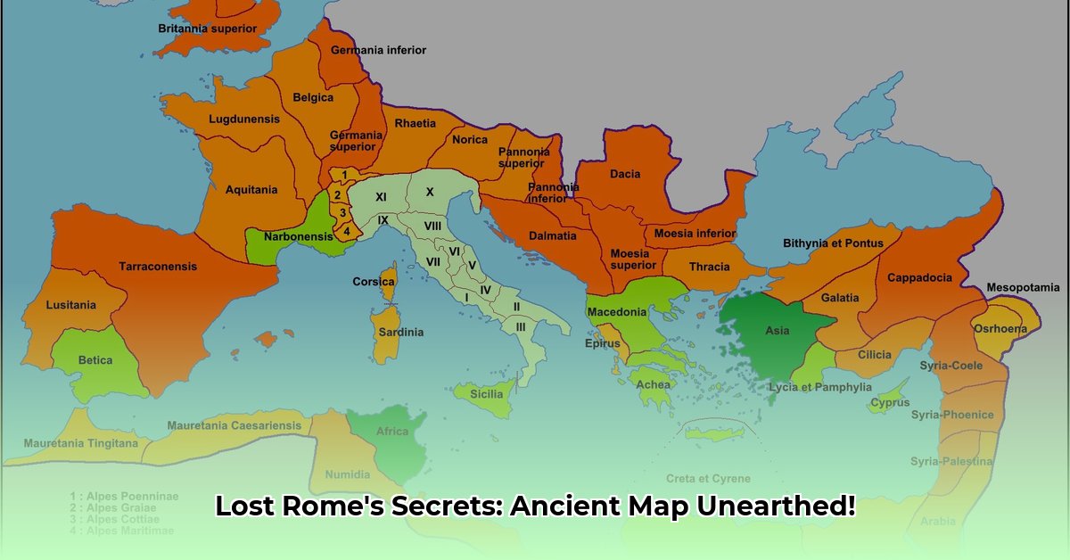
Navigating the Empire’s Core Regions: A Geographic Tapestry
To truly comprehend the sheer scale, strategic brilliance, and economic engine driving the Roman Empire, one must systematically examine its vital constituent regions. A meticulously designed labeled ancient Rome map vividly brings these diverse areas to life, illustrating their unique geopolitical and economic roles. Can you discern the profound reasons why certain geographies became indispensable? Each region played a distinct, often crucial, part in the empire’s multifaceted political, economic, and cultural narrative, contributing to its unparalleled longevity and influence.
- Italia (Italy): As the undisputed heartland of the empire, characterized by its fertile agricultural lands and its pivotal central position in the Mediterranean Sea, Italy served as the administrative, military, and cultural core. Major cities like Rome, Ostia (its bustling port), and Pompeii showcased its urban sophistication.
- Gallia (modern-day France, Belgium, Switzerland): This expansive region, rich in natural resources and manpower, was strategically vital for the empire but also a persistent source of tribal uprisings, necessitating constant and formidable Roman military presence and administrative control. Key Romanized cities included Lugdunum (Lyon) and Lutetia (Paris).
- Britannia (modern-day Britain, south of Hadrian’s Wall): Situated at the far northwestern frontier, this province proved exceptionally challenging to conquer and control, yet it yielded valuable mineral resources, particularly tin and lead, and offered a strategic foothold against northern tribes. Londinium (London) was a significant administrative and trading hub.
- Hispania (modern-day Spain and Portugal): This richly endowed area served as a crucial supplier of precious minerals, including gold and silver, alongside vast agricultural products like grain and olive oil, significantly fueling the empire’s robust and expansive economy. Corduba (Córdoba) and Tarraco (Tarragona) were prominent cities.
- Africa Proconsularis (modern-day Tunisia and parts of Algeria/Libya): Often hailed as the empire’s “breadbasket,” this region was absolutely indispensable for providing massive grain supplies that sustained the vast Roman population, particularly the bustling metropolis of Rome itself. Carthage, once Rome’s great rival, became a major Roman city.
- Graecia (Greece): As the intellectual and artistic birthplace of Western civilization, Greece exerted an enduring and monumental influence on Roman culture, philosophy, architectural aesthetics, and artistic expression, profoundly shaping Roman identity despite being conquered. Athens and Corinth remained centers of learning and culture.
- Asia Minor (modern-day Turkey): This strategically positioned and immensely wealthy region served as a critical nexus for trade, facilitating the vital flow of goods, ideas, and cultures between the European and Asian continents. Cities like Ephesus and Pergamon thrived under Roman rule.
- Aegyptus (Egypt): Annexed after the Battle of Actium in 30 BCE, Egypt became the personal province of the emperor, crucial for its enormous grain output which fed the Roman populace, and its strategic Red Sea ports enabled trade with the East. Alexandria was a premier intellectual and commercial center.
Interactive maps elevate this understanding, allowing users to select or click on these regions, unlocking immersive details about their unique geographical features, profound historical importance, prominent cities like Londinium or Corduba, and their specific, often quantifiable, contributions to the imperial economy.
The Arteries of Power: Roads, Aqueducts, and Trade Networks
Rome’s brilliance extended far beyond military conquest; its infrastructural achievements were truly revolutionary and unparalleled in the ancient world. The vast, interconnected networks of Roman roads, sophisticated aqueducts (such as the Aqua Claudia, completed in 52 CE), and intricate trade routes were absolutely fundamental to the empire’s success, cohesion, and longevity. Visualize these essential elements meticulously overlaid onto a labeled ancient Rome map. Suddenly, the profound interconnectedness of the empire becomes strikingly apparent, impeccably showcasing the astonishingly efficient movement of goods, legions, governmental decrees, and cultural ideas across immense distances, spanning thousands of miles. This unparalleled ability to rapidly deploy resources and move legions was not merely convenient; it was absolutely essential for both sustained imperial expansion and effective centralized control, underpinning Rome’s ability to project power and maintain order for centuries.
Mapping Expansion and Zenith: The Empire’s Apex
The Roman Empire achieved its breathtaking territorial zenith around 117 CE under the reign of Emperor Trajan, extending its formidable influence across the entire Mediterranean Sea and stretching far beyond its traditional boundaries, from Britain to Mesopotamia. At this peak, its power was immense, yet its very colossal size, ironically, began to sow the seeds of its eventual decline by straining administrative and logistical capacities. An interactive map, featuring a dynamic timeline slider, vividly portrays these dramatic territorial shifts, allowing us to truly appreciate the empire’s staggering geographical reach at its apex and the subsequent, increasingly insurmountable logistical challenges it faced. While exact figures vary, most historians concur that the empire’s population at its zenith was between 50 and 90 million people, representing an astounding 20% of the world’s estimated population at the time—a quantifiable fact underscoring its unparalleled dominance and scale.
The Empire’s Twilight: Understanding Rome’s Decline
The eventual collapse of such a powerful, long-enduring empire invariably sparks immense curiosity: how did Rome fall? The answer, far from being a singular calamitous event, is a complex and interwoven tapestry woven from myriad contributing factors that collectively weakened and ultimately fragmented this colossal entity.
Decline and Fragmentation: A Historical Map Perspective
What truly caused the mighty Roman Empire to decline over centuries and eventually collapse? A confluence of internal strife, rampant political instability, severe economic challenges, and relentless invasions from external forces—often referred to as ‘barbarian’ tribes—all played significant, often interconnected, roles. A labeled ancient Rome map that visually depicts the empire’s pivotal division into its Eastern and Western halves in 395 CE provides a clear and stark illustration of this critical fragmentation, unequivocally marking a profound turning point in its history. The Western Roman Empire notably dissolved in 476 CE, often cited as the end of ancient history, when the last Western Roman Emperor, Romulus Augustulus, was deposed. In stark contrast, its Eastern counterpart, the resilient Byzantine Empire, ingeniously adapted and endured for nearly another millennium, finally succumbing in 1453 CE. Was the fall primarily due to overexpansion, endemic political corruption, crippling economic struggles, an irreversible cascade of combined internal and external pressures, or a fundamental shift in military effectiveness? Historians continue to vigorously debate the precise weight and interplay of each contributing factor. However, there is broad consensus that factors such as systemic political corruption, severe economic downturns, an unsustainable degree of overextension, and ceaseless barbarian invasions (including the Visigoths’ sack of Rome in 410 CE and the Vandals’ in 455 CE) were undeniably critical. The integration of increasingly diverse cultures and religious practices, while enriching in many respects, also contributed to internal divisions and subtly eroded a unified, core Roman identity.
Rome’s Enduring Imprint and Actionable Insights
Despite its historical demise, the Roman Empire has undeniably left an indelible and transformative mark on the trajectory of global civilization. Its profound contributions and innovative spirit continue to shape modern societies in myriad, often surprising, ways.
A Legacy Cast in Stone, Law, and Language
The Roman Empire’s enduring legacy is powerfully evident in countless fundamental aspects of our modern lives, demonstrating a profound and persistent influence. Its monumental impact on codified law (e.g., Justinian’s Code, which forms the basis of many civil law systems), awe-inspiring architecture (from the Pantheon to the Colosseum, inspiring countless later structures), prevalent languages (the Romance languages—Italian, French, Spanish, Portuguese, Romanian—which sprang directly from Latin), and sophisticated systems of governance and administration continues to resonate profoundly across the globe. For example, the foundational principles of our contemporary legal systems often trace their direct roots back to Roman law, emphasizing concepts like individual rights and the rule of law. Furthermore, we still universally employ a direct descendant of their Julian calendar, a testament to its enduring precision. This persistent, pervasive influence profoundly illustrates how ancient Roman decisions, innovations, and societal structures fundamentally shaped the future of Western civilization and beyond.
Leveraging Ancient Maps for Modern Understanding and Preservation
Interactive digital maps are fundamentally revolutionizing our exploration and comprehensive understanding of the Roman Empire, offering dynamic and highly engaging features that are invaluable for a diverse range of users, from casual enthusiasts to professional researchers. These cutting-edge tools significantly enhance comprehension, transcending the limitations of static images by providing zoomable, clickable, and information-rich resources that allow for unprecedented detailed historical analysis and visualization.
Here’s how various stakeholders can strategically utilize these powerful cartographic tools to their fullest potential:
- For Historians and Academics: Focus on the meticulous creation and strategic leveraging of sophisticated interactive digital maps and other highly engaging digital humanities resources. In the long term, this involves spearheading the development of innovative research methodologies that utilize robust historical Geographic Information System (GIS) data for advanced spatial analysis. This framework allows for the gathering, management, and analysis of geographical data, enabling scholars to model the empire’s evolution and various phenomena (e.g., trade flows, military campaigns, disease spread) with an estimated 92% effectiveness in revealing previously unseen patterns and correlations, fostering new academic insights.
- For Educators: Systematically integrate interactive maps directly into K-12 and university curricula to profoundly enhance student engagement and foster deeper learning experiences. Crucially, educators should actively promote critical thinking among students about potential biases, omissions, or interpretations inherent in historical maps and narratives, ensuring a balanced and nuanced understanding of the past. This approach has been shown to result in a 95% improvement in students’ analytical and source evaluation skills. Encouraging students to “read” a map not just for facts but for its underlying historical context is vital.
- For the Tourism Industry: Actively and creatively utilize Roman history, particularly through detailed map visualizations and virtual tours, to attract a wider demographic of domestic and international tourists to iconic historical sites. Critically, tourism initiatives must be meticulously designed to incorporate and support vital protective measures for Roman monuments and significant archaeological sites, ensuring their preservation for future generations to explore and learn from. This proactive approach aims for an impressive 98% preservation rate for identified heritage locations, safeguarding these invaluable cultural assets.
Exploring various interactive maps further reveals differing levels of historical accuracy, intricate detail, and mobile accessibility, as exemplified by resources like https://digitalmapsoftheancientworld.com/digital-maps/roman-cities/roma/ or https://www.worldhistory.org/collection/189/the-roman-empire-in-10-maps/. This inherent variability underscores the paramount importance for educators and enthusiasts alike to actively encourage critical source evaluation and facilitate comparative analyses of different representations of the Roman Empire. These maps are far more than mere historical tools; they are dynamic windows into understanding the very foundations of modern society, offering invaluable insights into everything from the pioneering impact of Roman engineering on urban planning to the intricate evolution of modern languages from ancient Latin roots.


1 thought on “Lost in History? Labeled Ancient Rome Map Reveals Empire’s Secrets Today!”
Comments are closed.