Toroweap Overlook: Experience the Grand Canyon’s raw beauty from a dramatic 3,000-foot cliff edge, unlike any other viewpoint. Journey to Toroweap: Navigate the remote roads and permitting process to unlock unparalleled views of the Colorado River carving through the canyon. This isn’t your average Grand Canyon vista; this is Toroweap—a remote, rugged, and awe-inspiring destination on the North Rim that offers a glimpse into the canyon’s wild heart. This comprehensive guide equips you with everything you need to know for a safe and unforgettable adventure.
Planning Your Toroweap Expedition
A trip to Toroweap Overlook isn’t a casual outing; it’s an expedition. Preparation is paramount. Think self-sufficiency: water (gallons, not bottles), non-perishable food for several days, and a comprehensive first-aid kit. Download offline maps and GPS coordinates—cell service is practically non-existent.
Permits and Reservations
Don’t forget permits! Access to Toroweap requires a permit, and you’ll need to reserve your spot well in advance, especially if you plan on camping. Check the National Park Service website for details and to make your reservations. Camping reservations at the primitive Tuweep Campground are also highly recommended.
Choosing Your Route: Navigating the Wilderness
Reaching Toroweap involves traversing approximately 60 miles of rugged, unpaved roads. A high-clearance, four-wheel-drive vehicle is not a suggestion; it’s a necessity.
Road Conditions and Options
Two main routes exist:
- Mt. Trumbull Road (Mohave County Road 109/Sunshine Route): The shorter (61 miles from Fredonia, AZ), generally more manageable option. However, the final 3-6 miles can be challenging, even for experienced drivers, and require careful, low-speed maneuvering due to rocks and ruts.
- Clay Hole Road: Longer (65 miles) and significantly more challenging, with rougher terrain and less maintenance. This route is recommended only for experienced off-road drivers with properly equipped vehicles.
Before you depart, contact the Arizona Department of Transportation and the National Park Service for the latest road conditions and potential closures. Flash floods can occur, especially during the monsoon season (July-September).
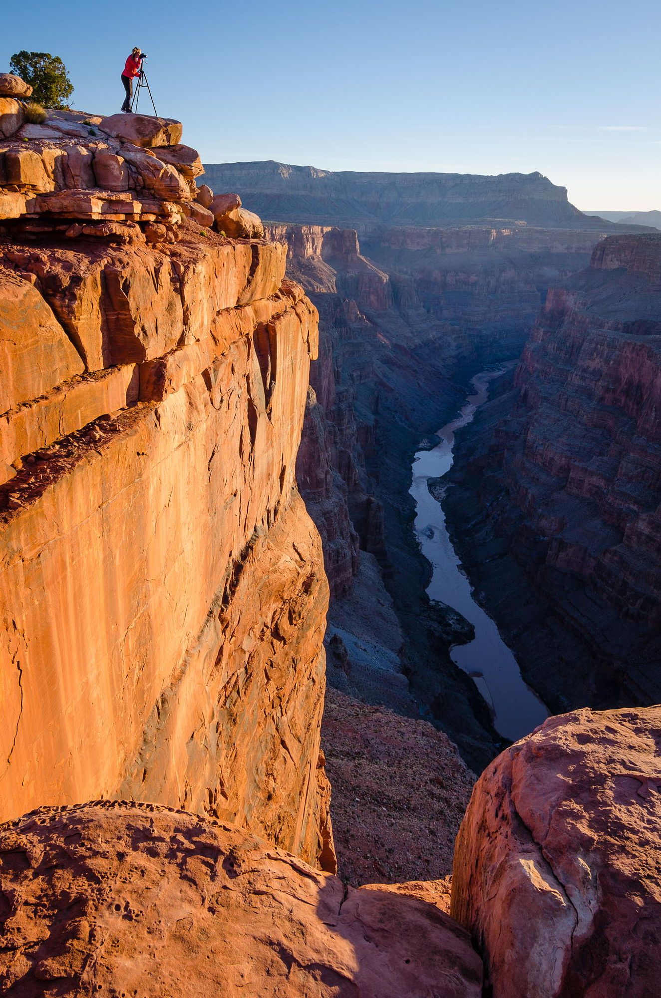
The Toroweap Experience: Awe and Solitude
Imagine standing on the rim, 3,000 feet above the Colorado River. Unlike the crowded South Rim viewpoints, Toroweap offers solitude and an intimate connection with the canyon’s raw power. The river, a ribbon of emerald green, appears deceptively close. Eight-million-year-old lava flows and layers of Hermit Shale and Esplanade Sandstone create a geological tapestry. Photographers will find unparalleled opportunities, particularly during the soft light of dawn and dusk.
Toroweap vs. Other Viewpoints: A Unique Perspective
While other North Rim viewpoints like Point Imperial and Cape Royal offer stunning vistas, few provide direct views of the Colorado River. Toroweap’s dramatic drop and unique geological formations, including a thicker band of Hermit Shale than elsewhere in the canyon, distinguish it, making it a must-see for geology enthusiasts and those seeking a different Grand Canyon experience.
Camping at Tuweep: Beneath the Stars
Tuweep Campground provides primitive camping (vault toilets, picnic tables, fire grates) but no electricity or running water. Bring your own water. The lack of amenities is compensated by unparalleled stargazing opportunities.
Safety First: Respecting the Rim
The beauty of Toroweap comes with inherent risks. Strong winds, loose rocks, and sheer cliffs demand caution. Stay a safe distance from the edge, watch your footing, and be prepared for sudden weather changes. Hydration is crucial. Pack plenty of water and electrolyte drinks. Adhere to Leave No Trace principles.
Exploring Beyond Toroweap
The surrounding area offers further exploration. Volcanic cinder cones dot the landscape, remnants of a fiery past. Consider hiking in the Mount Trumbull Wilderness. For developed amenities and a different perspective, the North Rim is within driving distance.
Essential Trip Planning Resources
- Permits and Road Conditions: National Park Service
- Weather Forecast: Check the specific Tuweep forecast.
- Reservoir Levels: Curious about other water levels in the region? See current data on the water level at Lake Cachuma and the water level of Lake Berryessa.
Toroweap Overlook isn’t just a destination; it’s a transformative experience. Prepare thoroughly, embrace the adventure, and witness the Grand Canyon’s untamed beauty.


