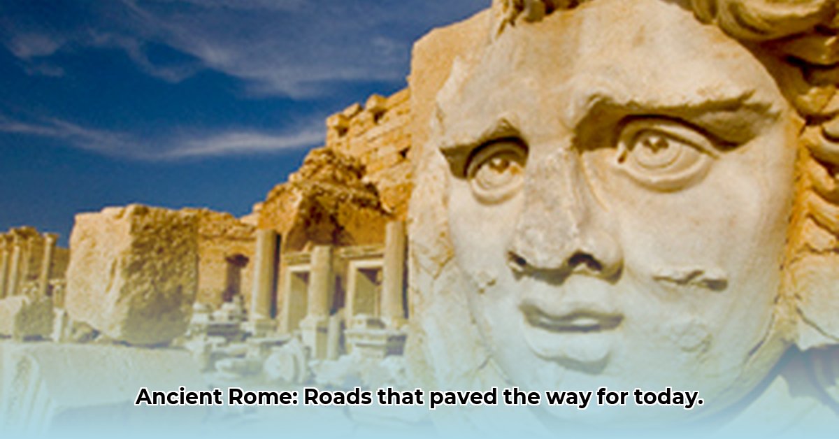
Ever wondered how a vast empire like ancient Rome maintained cohesion and power across immense distances? The answer lies not in magic, but in an unparalleled feat of civil engineering: its expansive network of roads. These were more than mere pathways; they were the arteries of an empire, facilitating military maneuvers, fostering economic prosperity, and enabling vital cultural exchange. Learn more about Roman road history. Get ready to explore how these ancient Roman infrastructure projects were meticulously planned and built, leaving a profound legacy that still influences modern transport and urban planning today.
Pillars of Power: Roman Roads and Imperial Ambition
Imagine attempting to govern a sprawling dominion without effective means of movement. It is a logistical nightmare. The Romans confronted this challenge head-on, constructing a system of Roman roads that became the backbone of their imperial control. These strategic importance routes allowed the formidable Roman legions to deploy rapidly and decisively, projecting power and maintaining order across diverse conquered territories. Without such rapid deployment capabilities, holding vast lands would have been nearly impossible.
Beyond military dominance, these road network arteries were instrumental in fueling economic growth. They facilitated the swift and secure transport of goods, from essential grains and valuable olive oil to fine wines, thereby integrating distant provincial economies into the heart of the empire. This efficiency in trade routes not only boosted prosperity but also solidified Rome’s influence. Furthermore, these roads were conduits for cultural exchange, carrying ideas, innovations, and customs throughout the Roman world, contributing to a unified imperial identity. The strategic framework behind these roads demonstrated a profound understanding of geography and the critical need to connect disparate regions.
The Appian Way (Via Appia), begun in 312 BCE by censor Appius Claudius Caecus, stands as a prime example. Linking Rome to Capua in a remarkably direct line, it later extended to Brundisium, reaching a length of 569 kilometers. Other famous roads like the Via Flaminia (Rome to Fano) and the Via Aemilia (Placentia to Aosta) radiated from the capital, illustrating Rome’s comprehensive approach to connectivity.
Engineered for Eternity: The Roman Road-Building Blueprint
What made these Roman roads so exceptionally durable, with many sections still visible millennia later? It was a testament to sophisticated Roman engineering and meticulous advanced construction techniques. The Romans prioritized longevity and functionality, designing roads with a layered approach that ensured both strength and effective drainage systems. According to Isidore of Seville, the Romans even borrowed construction knowledge for their viae munitae (built roads) from the Carthaginians and Etruscans, adapting and perfecting these techniques.
Here’s a look at their robust construction techniques, variations of which were adapted to local materials and terrain:
Surveying the Course: Expert surveyors, known as agrimensores, used tools like the groma and rigor to plot the straightest possible route. This often involved cutting through hills, traversing ravines, or even tunneling through mountains.
Dig Deep (Fossa): Engineers first excavated a trench, or fossa, down to bedrock or the firmest possible ground. The depth varied based on the terrain.
Lay the Foundation (Statumen): This bottom layer consisted of large, firmly packed stones, sometimes set in cement, providing a stable base. In marshy areas, wooden piles or rafted foundations might be used.
Intermediate Layers (Rudus and Nucleus): Above the Statumen came layers of smaller, compacted stones or gravel mixed with lime and mortar, forming a resilient core. The rudus was a coarse concrete layer, followed by the nucleus, a finer concrete.
Paving the Way (Summum Dorsum or Pavimentum): The final surface was laid with carefully fitted, often polygonal, stone slabs (like basalt or limestone), creating a remarkably smooth and hard-wearing surface. This crusta was crowned for drainage.
A critical aspect of their durable materials and design was the management of water. The cambered surface of the road, featuring a slight curve (or crown), directed rainwater to the sides. Side ditches then collected and channeled this water away from the roadbed, preventing erosion and preserving the integrity of the structure. In some instances, culverts—underground channels—were engineered to allow water to pass beneath the road, further preventing pooling. This meticulous attention to drainage was a primary factor in the longevity of Roman roads.
The Vast Network: Connecting an Empire from the Golden Milestone
The sheer scale of the Roman road network is astonishing, stretching over an estimated 400,000 kilometers (approximately 250,000 miles), with over 80,500 kilometers (50,000 miles) meticulously paved with stone. This monumental achievement symbolized Rome’s ambition and capability. At its peak, 29 major military highways radiated from the capital, and the empire’s 113 provinces were interconnected by 372 great roads. In Gaul alone, over 21,000 kilometers of roadways were improved, and in Britain, at least 4,000 kilometers.
At the literal and symbolic heart of this sprawling system was the Miliarium Aureum, or Golden Milestone, located in the Roman Forum. Erected by Augustus in 20 BCE, this gilded bronze monument served as the central point from which all distances along Roman communication lines were measured, underscoring Rome’s centralized strategic planning. Constantine later dubbed it the umbilicus Romae (“navel of Rome”).
The legal frameworks governing road usage further highlight the profound importance of these arteries to Roman daily life and governance. Roman law defined the right to use a road as a servitus. The ius eundi (“right of going”) established a claim to use a footpath (iter) across private land, while the ius agendi (“right of driving”) referred to a carriage track (actus). A via combined both, provided it was of the proper width (often around 12 Roman feet for public rural roads, allowing two carts to pass). These regulations underscore the road system’s fundamental role in Roman society and commerce, enabling sustained economic prosperity and administrative efficiency.
Feature
Description
Total Length
Over 400,000 kilometers (approximately 250,000 miles) across the entire Roman Empire.
Paved Sections
A substantial portion, over 80,500 kilometers (50,000 miles), was meticulously paved with stone, exemplifying Roman commitment to durable infrastructure.
Central Hub
The Miliarium Aureum (Golden Milestone) in Rome served as the symbolic and practical origin point for all distance measurements across the empire’s roads, marking distances to major cities.
Legal Regulations
Legal statutes like ius eundi (the right to travel) and ius agendi (the right to conduct business) underscored the vital role of roads in Roman society and commerce, defining rights of passage.
Military Use
The robust roads enabled the rapid deployment of Roman legions and essential supplies, which was indispensable for maintaining military control, securing new territories, and ensuring swift responses to threats throughout the vast empire.
Economic Impact
Facilitated vast trade routes and the efficient transport of diverse goods (e.g., grain, olive oil, wine), fostering economic growth and integrating regional markets under a common imperial system, leading to widespread prosperity.
Communication
Ensured the swift and reliable delivery of messages and information via the cursus publicus (public postal service), crucial for effective governance and administration across the vast Roman world and maintaining imperial cohesion.
Travel Speed
Horse-drawn carts could travel 40-50 kilometers (25-31 miles) per day, while pedestrians typically covered 20-25 kilometers (12-16 miles) per day on these efficient routes.
Cartography & Itineraries
The Romans meticulously mapped their network; the Itinerarium Antonini listed towns and distances, while the Tabula Peutingeriana offered a schematic route-planner, essential for travelers and administrators.
Beyond the Main Roads: A Hierarchy of Pathways
Roman roads were not monolithic; they varied significantly in their character and purpose. Ulpian, a Roman jurist, categorized them into three main types, reflecting their ownership, maintenance, and use:
Viae Publicae(Public Roads): Also known as consulares, praetoriae, or militares, these were the high or main roads, constructed and maintained at public expense, with their soil vested in the state. They typically connected major cities, military bases, public rivers, or the sea. Often named after the censor who commissioned them (e.g., Via Appia), they were managed by curatores (commissioners) and repaired by redemptores (contractors).
Viae Privatae(Private Roads): Also called rusticae (country roads), glareae (gravel roads), or agrariae, these were originally built by private individuals, who retained ownership but could dedicate them to public use. They typically led from public roads to specific estates or settlements. Some were paved, while others were left unpaved with a gravel surface (viae glareae) or were simple dirt roads (viae terrenae).
Viae Vicinales(Village Roads): These roads ran through or towards a vicus (village or district), connecting to main roads or other viae vicinales. Their public or private status depended on their original funding. Maintenance typically fell to the magistri pagorum (magistrates of the cantons), who could require neighboring landowners to contribute labor or maintain sections passing through their property.
Life on the Roman Road: Services and Travel
The Roman road system supported a sophisticated network of services for travelers, showcasing an advanced understanding of logistics and human needs.
Mansiones(Way Stations): For officials and those on imperial business, the government provided mansiones every 25-30 kilometers (16-19 miles). These complete villas offered lodging, food, and refreshment, often becoming centers around which towns or military camps grew.
Cauponae(Inns/Taverns): For non-official travelers, private inns called cauponae offered basic lodging and services. While sometimes disreputable, they were common along the roads.
Mutationes(Changing Stations): Located every 20-30 kilometers (12-19 miles), these complexes allowed travelers to change horses or vehicles and access services like wheelwrights, cartwrights, and equarii medici (veterinarians). This system facilitated incredibly swift travel for urgent matters, such as Tiberius’s dash of 296 kilometers in 24 hours to reach his dying brother.
Vehicles of the Roman World: The roads catered to a variety of conveyances.
* Cars: The carrus was a standard open chariot for one or two people, with iron tires. The more luxurious carpentum was a covered version for women and officials. The light cisium, akin to a gig, was used for cab work.
* Coaches: The raeda (or reda) was the primary four-wheeled coach for travel, carrying several people and luggage up to 328 kilograms (723 pounds). Raedae meritoriae were hired coaches, and fiscalis raeda were government vehicles.
* Carts: The plaustrum (or plostrum) was a simple flatbed cart, often with solid wheels, used for cargo. The military used a standardized wagon called the carrus clabularius for transporting impedimenta (baggage).
Postal Services: The cursus publicus, founded by Augustus, was the public postal service, carrying official mail by relay, achieving speeds of 80 kilometers (50 miles) a day. Private mail was handled by tabellarii, an organization of slaves.
Building an Empire: Administration and Maintenance
The construction and care of Roman roads were considered functions of immense importance throughout Roman history, initially under the paramount authority of the censors, Rome’s most venerable magistrates. They oversaw contracts for paving streets and laying gravel roads.
Over time, as the Roman dominions expanded, the responsibility devolved:
* Italy: Censorial duties passed to army commanders and special commissioners, and sometimes local magistrates.
* Provinces: The consul or praetor and their legates handled contractors directly.
* Rome: Within the city, specialized bodies like the Quattuorviri viis in urbe purgandis (four men for clearing streets within the city) and Duoviri viis extra urbem purgandis (two men for clearing roads outside the city) were established. Householders were even legally responsible for repairs to the street passing their own homes.
Augustus, recognizing the inefficiency of existing structures, reformed the administration. He appointed permanent curatores (superintendents) of senatorial or equestrian rank for each great public road. These officials issued contracts, ensured quality, and even tackled issues like sewer construction and traffic obstruction. Financing road building was a state responsibility, with maintenance often falling to the provinces, supplemented by contributions from private citizens, high officials, and even censors who contributed suâ pecuniâ (with their own money).
Conquering Terrain: Roman Engineering Masterpieces
Romans preferred to engineer solutions to obstacles rather than circumvent them, a hallmark of their practical and ambitious approach to construction.
Cuts and Tunnels: Outcrops of stone, ravines, or mountains called for direct cuts and tunnels. A remarkable example is the Roman road near Căzănești at the Iron Gates, half-carved into rock, with the other half projecting over the Danube via a wooden structure. Notable tunnels include Cumaea (1,000 m), Cripta Neapolitano (705 m), and Grotta di Seiano (780 m), often constructed by precise counter-excavation from both ends.
Bridges (Pontes): Roman bridges were some of the first large and lasting structures of their kind, often using concrete and robust stone arches. Many, like the Milvian Bridge in Rome (109 BCE) or the bridge over the River Tagus at Alcantara (106 BCE), remain in use today. The bridge at Narni, 180 meters long and 33 meters high with massive arches, demonstrates their mastery of large-span construction.
Causeways: Over marshy ground, causeways were built by sinking large quantities of stone to raise the roadbed several feet above the marsh. In provinces, log roads (pontes longi) were sometimes used.
These engineering solutions allowed for the directness and efficiency that defined the Roman road network, overcoming geographical challenges with boldness and ingenuity.
Paving the Future: The Enduring Legacy of Roman Infrastructure
Why should we continue to study these ancient pathways? Because the influence of Roman roads is unmistakably present in our world today. Their principles of strategic connectivity, robust durable materials, and efficient design continue to inform modern civil engineering practices and infrastructure development. Many modern roads, particularly in Europe, still follow the ancient Roman alignments, a testament to their enduring and insightful strategic planning.
The innovative spirit of the Romans offers valuable lessons for various contemporary fields:
Stakeholders & Focus
Key Lessons from Roman Roads
Civil Engineers
Durability & Longevity: The layered construction, use of aggregate, and superior lime-based mortars (some containing volcanic ash, similar to pozzolana) resulted in structures resistant to weathering and decay for millennia. Modern engineers study Roman concrete to develop more sustainable and long-lasting materials. Drainage Systems: Roman emphasis on cambered surfaces, side ditches, and culverts for water management remains a cornerstone of effective road design.
Urban Planners
Strategic Connectivity: The Roman understanding that infrastructure connects disparate regions, facilitates trade, and ensures military and administrative control is foundational for modern regional planning. Integrated Services: The provision of way stations and support services along major routes highlights the importance of comprehensive planning beyond just the physical road.
Policymakers
Long-Term Investment: Rome’s commitment to building durable, high-quality infrastructure for centuries, despite initial costs, yielded immense strategic,
Hello, My love for writing is rivaled only by my passion for in-depth research. While many may skim the surface, I dive deep, seeking the hidden gems of information that give a story texture and depth. Every word I write is backed by hours of exploration, ensuring that my work is not just compelling, but also meticulously accurate. Join me on a journey where every piece is a deep dive into the realms of knowledge and storytelling.