Have you ever wondered what life was really like in ancient Troy? Ditch the dusty history books! Let’s embark on an exciting adventure, using maps as our time machines to explore this legendary city. We’ll journey through its various eras, tracing Troy’s growth and transformations from its humble beginnings to its dramatic fall. We’ll uncover its secrets – the magnificent structures, the bustling marketplaces, and the lives of the people who lived, loved, and fought there. Get ready to blend history, archaeology, and a touch of mythology as we bring ancient Troy to life! For a broader view of the ancient world, check out this ancient world map.
Troy’s Strategic Geography and Enduring Archaeological Significance
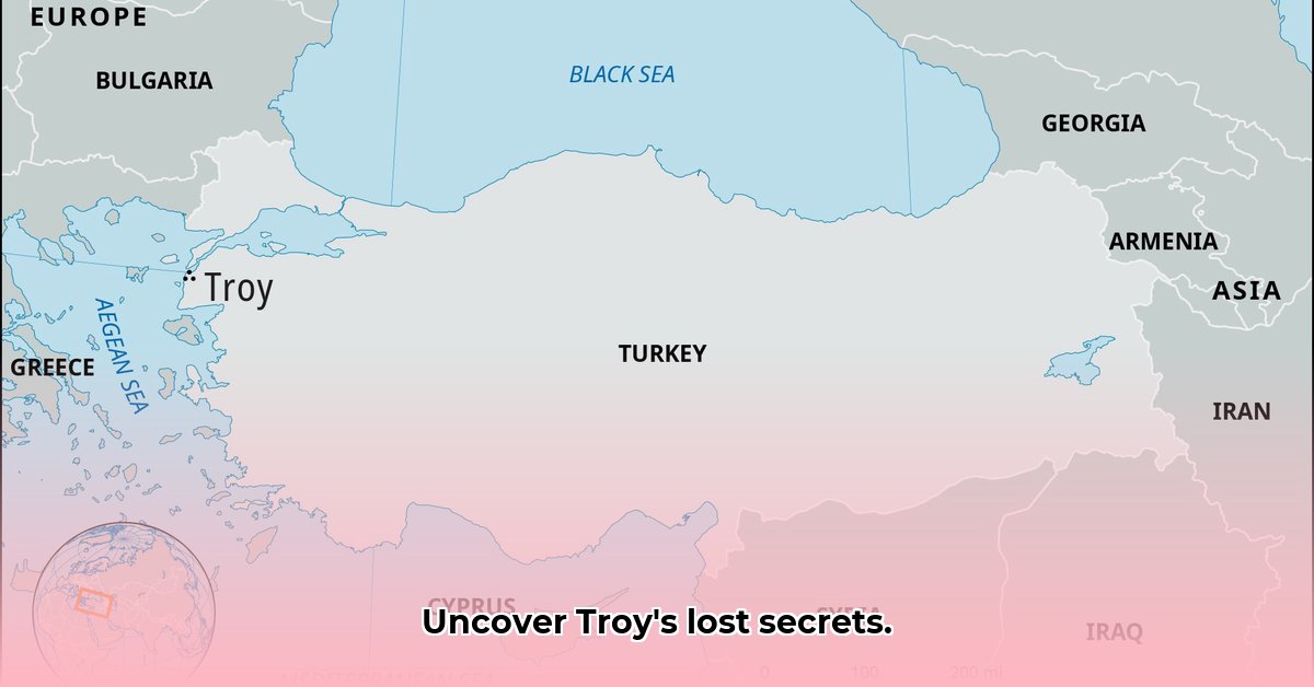
Imagine a city built layer upon layer, each representing centuries of human endeavor. That’s Troy, strategically located on the mound of Hisarlik in modern-day Turkey. Archaeologists have unearthed the remains of not one, but nine distinct cities, each built upon the ruins of its predecessor! It’s like an archaeological layer cake, with each stratum offering unique insights into a different historical period.
Visualizing this complex history requires more than just words. An ancient Troy map, depicting each of these nine layers, would be an invaluable tool for understanding the city’s evolution. However, can any map truly capture the essence of Homer’s legendary Troy? The challenge lies in reconciling the epic tales with the tangible archaeological evidence. The stories and the findings don’t always align perfectly, leading to ongoing scholarly debates and interpretations.
Deciphering Troy’s Past: Stratigraphy and Archaeological Discoveries
Archaeologists meticulously piece together Troy’s intricate puzzle using a variety of tools and techniques, from ground-penetrating radar to precise dating methods. Each layer they excavate reveals valuable clues about the lives of Troy’s inhabitants. For example, the imposing walls of Troy VI attest to a city that prioritized defense and military strength. Meanwhile, Troy II is renowned for the discovery of “Priam’s Treasure”—a collection of exquisite gold artifacts, the significance of which remains a subject of both fascination and debate.
These archaeological finds provide compelling evidence of Troy’s thriving trade connections with lands across the Mediterranean. A well-designed ancient Troy map could highlight the locations of significant buildings and structures, placing them within their respective historical periods. It could also illustrate the extent of Troy’s trade networks, showcasing its connections to the wider ancient world.
The Strategic Importance of Troy’s Location: A Gateway Between Worlds
Troy’s strategic location was a key factor in its prosperity and influence. Situated near the Dardanelles strait, the city controlled a crucial waterway linking the Aegean and Black Seas. In essence, Troy served as a toll booth for ancient ships, allowing it to exert control over a significant portion of maritime trade. This control brought wealth and power to the city, attracting merchants, travelers, and even invaders.
The artifacts unearthed at Troy showcase the diverse range of goods that passed through its gates, originating from all corners of the ancient world. A detailed map could highlight these trade routes, illustrating Troy’s pivotal role in connecting East and West. But was this powerful economy the key to Troy’s legendary wealth and, ultimately, its downfall, as suggested in Homer’s Iliad? The debate continues to this day, with scholars offering various interpretations of the city’s rise and fall.
Daily Life in Troy: Houses, Walls, and Society
The ruins of Troy offer tantalizing glimpses into the daily lives of its inhabitants. The wealthy elite resided in megaron houses—grand residences featuring a central hall that served as a focal point for social and political gatherings. These impressive homes, along with the city’s formidable walls, provide valuable insights into Troy’s social structure and military capabilities.
A comprehensive ancient Troy map could illustrate how these features fit together, giving us a clearer picture of life in this ancient city. Did this societal layout align with the descriptions provided by Homer in the Iliad? Connecting the archaeological evidence with the epic poems is a complex and ongoing challenge for researchers.
Mapping the Unknown: Challenges and Interpretations
While archaeologists have made remarkable discoveries at Troy, pinpointing exactly which layer corresponds to the Troy of Homer’s epic stories remains a subject of intense debate. Some scholars argue in favor of Troy VIIa, while others contend that Troy VI is a more likely candidate. This disagreement underscores the inherent challenges in interpreting archaeological evidence and comparing it to ancient texts.
A truly helpful ancient Troy map would acknowledge this uncertainty, presenting multiple possibilities and highlighting areas where further research is needed. It would serve as a dynamic tool for exploration, encouraging users to engage with the evidence and form their own informed opinions.
The Enduring Legacy of Troy: Ongoing Exploration and Future Discoveries
The exploration of Troy is an ongoing endeavor, with scientists continuing to unearth new clues and expand our understanding of the Bronze Age Aegean world. Questions surrounding Troy’s relationship with the Hittite Empire, and the accuracy of Homer’s account, remain fascinating areas of inquiry.
One thing is certain: Troy was a major player in the Late Bronze Age, a city of strategic importance and cultural significance. With the advent of new technologies and increasing collaboration between experts from various disciplines, future ancient Troy maps will undoubtedly become even more precise and informative. The story of Troy is a complex puzzle, and we are still piecing it together, one discovery at a time. It’s a story that continues to evolve as we learn more about this legendary city.
- Troy was a significant Bronze Age city with a strategic location.
- Archaeological layers at Hisarlik reveal nine distinct settlements.
- Mapping Troy involves integrating historical texts and archaeological evidence.
The Impact of Trade Networks on Troy’s Historical Development
Key Takeaways:
- Troy’s strategic location fueled its economic success.
- Extensive trade networks connected Troy to diverse civilizations.
- Artifacts reveal a vibrant exchange of goods and ideas.
A Crossroads of Civilizations: Troy’s Strategic Importance
Picture a bustling port city, a melting pot of cultures and commerce. That was Troy, strategically positioned at the gateway to the Dardanelles strait. Its location alone dictated its destiny. How did trade networks impact the development of Troy throughout its history? The answer lies in the constant flow of goods and people through its gates. Archaeological excavations at Hisarlık reveal a captivating story of interconnectedness. Pottery shards from Crete, intricate metalwork from Cyprus, and even exotic Egyptian artifacts—all unearthed within Troy’s walls—bear witness to its extensive trading relationships. These weren’t just isolated exchanges; they were integral to Troy’s very existence.
Economic Prosperity: Troy’s Role in the Late Bronze Age
Troy was more than just a passive recipient of goods. It played an active role, serving as a key intermediary in the complex trading web of the Late Bronze Age. Raw materials, such as timber and minerals, were likely among its exports. Did this trade contribute to Troy’s legendary wealth? Undoubtedly, it contributed significantly to its prosperity. The scale and complexity of Troy’s settlements suggest a thriving economy fueled by trade. However, the precise extent of Troy’s economic influence within the broader Bronze Age remains a subject of ongoing scholarly debate.
The Hittites and Beyond: Exploring Troy’s External Relations
Troy’s trade connections extended far beyond the Aegean. The Hittite Empire, a formidable power in Anatolia, exerted considerable influence over Troy’s economic landscape. Hittite records mention Troy, suggesting the existence of diplomatic and possibly economic ties between the two powers. Was Troy a loyal ally, a reluctant vassal, or something in between? Their interaction provides a compelling case study in the intricacies of Bronze Age geopolitics. The influence of Mycenaean Greece on Troy is equally intriguing, evidenced by the discovery of Mycenaean artifacts at the site. Was this evidence of amicable trade relations, or a reflection of a more complex military or political dynamic?
The Trojan War: Myth and Reality in Ancient Trade
The legendary Trojan War, immortalized in Homer’s Iliad, casts a long shadow over Troy’s history. But did the war significantly impact its trade networks? The destruction of Troy VIIa, often associated with the Trojan War, undoubtedly disrupted economic activity. The “reality” of the war versus its mythic interpretation remains a point of contention among historians and archaeologists. Was the destruction caused by a prolonged siege, a devastating earthquake, or a combination of both? Regardless of the exact cause, the event undeniably affected the flow of goods and people through the city.
A Legacy of Trade: Troy’s Enduring Significance
How did trade networks impact the development of Troy throughout its history? The answer is multifaceted. These networks fueled its economic prosperity, facilitated cultural exchange, and shaped its political landscape. Troy’s story is not merely that of a single city, but a microcosm of the interconnected world of the Late Bronze Age. The ongoing research and excavations at Hisarlık promise to further illuminate the intricate relationship between trade and the rise and fall of this legendary city.
- Troy’s location made it a key trade hub in the Late Bronze Age.
- Archaeological evidence reveals trade connections with various civilizations.
- The Trojan War’s impact on trade networks is still debated by researchers.
Troy’s Architectural Marvels Across Eras: A Testament to Innovation
Key Takeaways:
- Troy’s strategic location near the Dardanelles shaped its history across millennia.
- Nine distinct settlements (Troy I-IX) showcase evolving architectural styles.
- Troy’s Architectural Marvels Across Eras stand as a testament to engineering.
A City Forged in Time: The Strata of Troy
Imagine a city built not just over centuries, but millennia. That’s Troy. Located strategically near the Dardanelles Strait, this ancient city thrived—and was rebuilt—repeatedly. Excavations at Hisarlık have revealed nine distinct layers of settlement, each telling a unique story. From humble beginnings (Troy I) to impressive fortifications (Troy VI), the evolving architecture mirrors societal progress, technological advancement, and shifts in power dynamics. We’re not just looking at stones and mortar; we’re observing a living, breathing society unfolding before our eyes.
From Humble Beginnings to Fortified Strongholds: The Evolution of Troy’s Defenses
The earliest settlements at Troy, such as Troy I and II, featured smaller, simpler structures. Their walls, though substantial for their time, pale in comparison to the massive fortifications of later periods. Troy VI, for instance, boasts an impressive 550-meter circuit of walls, significantly larger than its predecessors. The construction techniques also advanced considerably over time. The shift from rudimentary mud-brick walls to precisely cut ashlar blocks in Troy VI demonstrates significant technological progress and a greater investment in defense.
Megarons, Temples, and Everyday Life: Peeking into Trojan Society
The architecture of Troy wasn’t solely about defense; it also served social and cultural functions. The megarons (large rectangular halls) were central to the social and political life of the city. These structures, found throughout various Troy periods, served as meeting places, residences for elites, and possibly even religious centers. We also find evidence of temples dedicated to deities like Athena. These religious structures, along with other public buildings like odeons (concert halls), provide glimpses into the civic and cultural life of the inhabitants. The smaller, more modest houses, where the majority of the population resided, offer valuable insights into the daily lives of ordinary Trojans.
The Puzzle of Troy VIIa and the Trojan War: Architectural Impacts
Troy VIIa holds a special place in our narrative due to its chronological alignment with the proposed timeframe of the Trojan War. It inevitably becomes a focal point of debate and speculation. Archaeological evidence reveals significant destruction during this period, but the exact extent of this remains a point of scholarly contention. The presence of pithoi (large storage jars) in this layer suggests the possibility of a siege or proactive preparations for food scarcity.
A Legacy Etched in Stone: Understanding Architectural Significance
From the humble settlements of the Early Bronze Age to the powerful city-state of the Late Bronze Age, Troy’s architecture stands as a testament to human ingenuity and resilience. Each layer adds a piece to the complex puzzle of this ancient city. Troy’s Architectural Marvels Across Eras aren’t just impressive structures; they are snapshots of a society’s evolution, reflecting its political structures, religious beliefs, technological advancements, and interactions with the larger world.
- Troy’s architectural layers showcase its societal evolution.
- Defensive structures evolved from simple walls to massive fortifications.
- Megarons and temples reflect Troy’s social, political, and religious life.
The Significance of Trade Networks in Shaping Ancient Troy
Key Takeaways:
- Troy’s location at the Dardanelles was crucial for trade.
- Archaeological finds show extensive trade connections.
- Further research is needed to understand Troy’s influence.
A Crossroads of Empires: The Power of Geographic Advantage
Imagine a city strategically perched at the crossroads between two vast seas. This was Troy, its location at the narrow Dardanelles strait granting it access to the Aegean Sea, the Black Sea, and the Eastern Mediterranean trade routes. This geographical advantage fueled its prosperity, connecting it to diverse civilizations for centuries. But was Troy merely a beneficiary of its prime location, or did it actively shape Trade Networks Shaping Ancient Troy’s Development?
The Archaeological Evidence: Unearthing Clues from the Past
Archaeological excavations at Hisarlik reveal a rich tapestry of imported goods, providing tangible evidence of Troy’s vibrant trade connections. We find artifacts originating from Egypt, Crete, Cyprus, and the Greek mainland, hinting at a sophisticated network of exchange. Do these items represent the spoils of war, diplomatic gifts exchanged between rulers, or the products of robust commercial trade? Each possibility adds to the complexity of the story. The sheer volume of these imported goods demonstrates that Troy was deeply enmeshed in regional and intercontinental trade.
The Great Debate: Hub or Outpost? Considering Troy’s Economic Role
The interpretation of Troy’s role within these Trade Networks Shaping Ancient Troy’s Development remains a contested issue among scholars. Some envision Troy as a major commercial hub, actively controlling the flow of goods and exerting its influence over trade routes. Others suggest that it played a more peripheral role, perhaps lacking the infrastructure and resources necessary to function as a major trading center. The relative lack of conclusive evidence for large-scale commercial structures at Troy fuels this ongoing debate.
Unraveling the Mystery: The Importance of Further Research
The uncertainty surrounding Troy’s precise role underscores the inherent challenges in reconstructing ancient economies. Limited textual and archaeological evidence, combined with ongoing debates about the precise structure of Bronze Age trade, means that we are still piecing together the puzzle. Further analysis of Trojan artifacts, coupled with advanced modeling of ancient trade routes, will be crucial for resolving this enigma and gaining a more complete understanding of Troy’s economic significance.
The Enduring Legacy: Understanding Troy’s Lasting Influence
Regardless of its precise role within these networks, Troy’s participation in the vibrant exchange of goods and ideas during the Late Bronze Age left an indelible mark on the region. It represents a fascinating case study, highlighting the complex interplay between geography, politics, and economics in shaping the development of a major ancient city.
- Troy’s location at the Dardanelles provided access to key trade routes.
- Imported goods found at Hisarlik suggest extensive trade connections.
- Scholars debate whether Troy was a major trade hub or a smaller outpost.


