Have you ever wondered what it was like to walk the streets of an ancient Greek city? Imagine the hustle and bustle of trade, the vibrant marketplace, and the towering structures that once defined Corinth. This isn’t just a history lesson; it’s an exploration of how maps, combined with archaeological discoveries and historical accounts, can unlock the secrets of this remarkable city. For a similar example, check out this Ancient Athens map. Join us on a journey through time as we delve into the ancient maps of Corinth, revealing its strategic importance, its economic powerhouse status, its urban development, and even its enduring legacy.
Tracing Corinth’s Rise to Power Through Ancient Maps
Corinth. The very name evokes images of ancient grandeur and bustling commerce. To truly comprehend the significance of this city, we must go beyond the myths and legends and examine the historical evidence, especially the ancient maps of Corinth. These aren’t just simple drawings; they are invaluable records that provide insights into the city’s pivotal role in the Mediterranean world. They are time capsules, preserving details of a civilization at its zenith and, later, its gradual decline. Let’s embark on a journey into historical cartography and unearth the stories embedded within these maps.
The Isthmus Advantage: Corinth’s Strategic Masterstroke
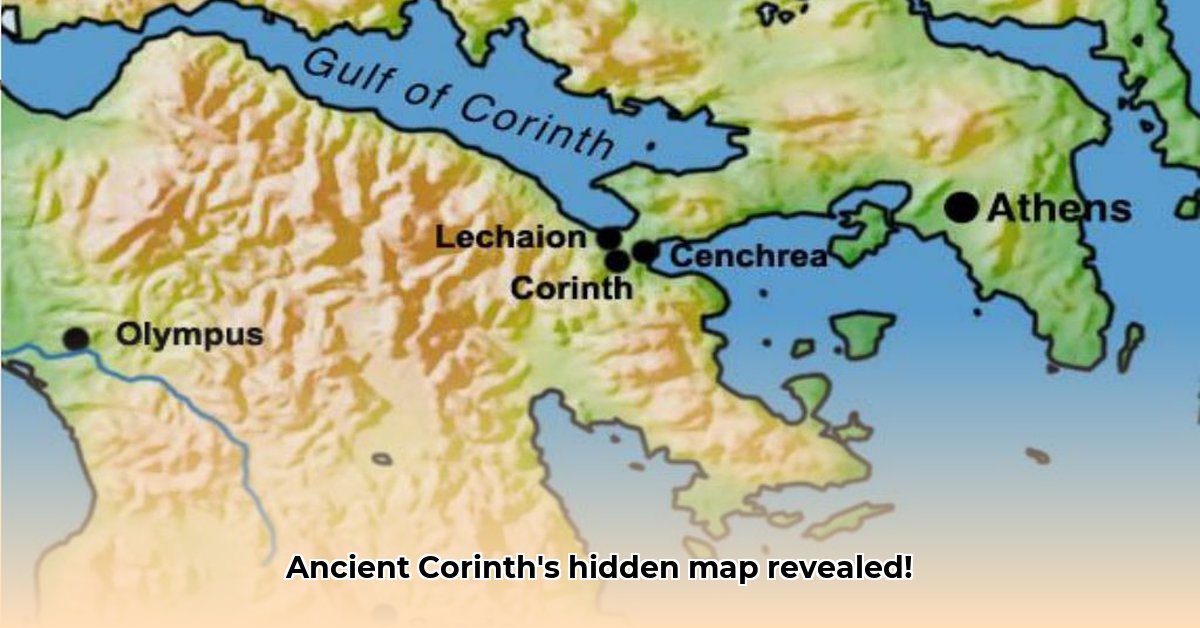
Envision a city strategically positioned on the Isthmus of Corinth, the narrow land bridge connecting the Peloponnese peninsula to mainland Greece. This geographical advantage was the key to Corinth’s success. Its location between the Aegean and Ionian Seas transformed it into a natural crossroads for trade and maritime activity. Ancient Corinth maps vividly illustrate this advantage, showcasing the intricate network of trade routes emanating from the city like spokes on a wheel, linking it to distant parts of the Mediterranean. However, geography alone wasn’t enough. Astute political maneuvering and strong leadership were essential ingredients in Corinth’s recipe for success. This combination propelled Corinth into a position of unrivaled strength and influence, making it a force to be reckoned with in the ancient world. Let’s not underestimate the pivotal role of maritime commerce in Corinth’s ascent.
Deciphering Ancient Maps: A Window into Corinthian Life
It’s important to acknowledge that these ancient maps aren’t perfectly accurate representations in the modern sense. They are stylized portrayals that capture the essence of the city, not precise blueprints. Nevertheless, their study provides an unparalleled glimpse into daily life in ancient Corinth. We can discern the city’s layout, the bustling agora (marketplace), the impressive temples dedicated to various gods, and the bustling harbors teeming with ships. The maps also reveal the defensive walls, hinting at the city’s vulnerabilities and its commitment to protection. They even depict the Diolkos, a remarkable engineering feat that facilitated the transport of ships across the Isthmus, saving considerable time and boosting the city’s economic prowess. By comparing maps from different historical periods, we can reconstruct the city’s evolution, its periods of growth, its triumphs, and its eventual decline. The ingenuity of Corinthian urban planning is truly remarkable.
The Diolkos: An Ancient Engineering Marvel and Economic Driver
The Diolkos, this ingenious paved trackway across the Isthmus, was more than just a shortcut; it was the lifeblood of Corinth’s economy. Imagine the spectacle of ships being hauled across the land, merchants haggling over prices, and laborers working tirelessly—all essential components of the city’s thriving trading machine. By circumventing the long and perilous sea voyage around the Peloponnese, the Diolkos significantly reduced travel times and costs. Ancient maps reflect the Diolkos‘s importance, with later versions often showcasing its expansion and development, testament to its impact on the city’s prosperity. Did you know it functioned as an ancient form of supply chain management, streamlining trade and commerce?
Corinth’s Decline and Enduring Legacy: A Story of Resilience
Even a city as strategically advantageous and economically powerful as Corinth couldn’t escape the vagaries of history. Recurring wars, internal strife, and, ultimately, Roman conquest led to its decline. Later maps reflect this downturn, depicting changes in the city’s boundaries and possibly even signs of physical damage. Yet, even in its decline, Corinth left an indelible mark on the world. Its artistic achievements, particularly its renowned pottery, continue to be celebrated today. Its significance in the early days of Christianity, through the visits of St. Paul, has left a lasting impact on religious history. The ancient maps of Corinth, therefore, are more than just geographical records; they are narratives of a civilization’s rise and fall, a testament to human ambition, innovation, and our shared history. This is a compelling example of historical resilience in the face of adversity.
Archaeological Evidence: Validating and Challenging Cartographic Records
Ongoing archaeological excavations continue to uncover valuable artifacts that either corroborate or challenge the information presented on ancient maps. Discoveries such as intricate mosaics, pottery shards, and sculptures help us construct a more complete picture of Corinthian life, filling in details that the maps may omit or couldn’t represent. For instance, the sheer abundance of pottery unearthed provides compelling confirmation of the scale of Corinth’s trading network, as highlighted in the maps. Does the archaeological record always align perfectly with the cartographic evidence, and how do we reconcile any discrepancies that may arise? This highlights the importance of ancient trade routes and their far-reaching influence.
Ongoing Research: Unveiling Hidden Insights
The study of ancient Corinthian maps is a dynamic and constantly evolving field. With new archaeological discoveries being made and advanced technologies being employed, our understanding of this fascinating city is continually deepening. The combination of meticulous map analysis with ongoing archaeological work holds the promise of revealing even more about ancient Corinth’s vibrant past. Ongoing research may unveil previously unknown aspects of the city’s daily life, its political structures, its cultural interactions, and perhaps shed light on details that appear ambiguous or contradictory in the existing maps. The story of ancient Corinth is far from complete. What future insights might archaeological discoveries bring to light?
The Apostle Paul’s Enduring Impact on Ancient Corinth
Corinth, a bustling hub in the ancient world, flourished as a major trading center and a melting pot of cultures. Its strategic location on the Isthmus, connecting the Peloponnese peninsula to mainland Greece, fueled its prosperity. But how did a single individual, a first-century missionary, leave such an enduring mark on this powerful city? Let’s explore the role of Christianity in the Ancient World and its influence on Corinth.
Corinth: A City of Contrasts and Opportunities
Imagine Corinth at its height. The air thrummed with activity—merchants bartering goods, craftsmen practicing their trades, and the sounds of daily life echoing through the streets. Archaeological excavations reveal a sophisticated urban plan, with impressive public buildings, a thriving marketplace, and a significant Jewish population. These features align perfectly with the accounts of Corinth in the Bible. The very ground beneath our feet tells stories of its vibrant past. Let’s understand New Testament Archaeology and its ability to shed light on biblical accounts.
The well-known Gallio inscription, while not explicitly referencing Paul, provides crucial context, confirming Roman authority in Achaia during the period of Paul’s ministry. This historical record forms a cornerstone in piecing together the puzzle of Paul’s influence. Did these historical records, however, fully capture the impact of Paul’s teachings? Probably not. This understanding is critical for comprehending Roman governance and its impact on local populations.
Paul’s Transformative Presence: A Ripple Effect
Paul’s arrival in Corinth was more than just a brief visit. His extended stay, detailed in the Acts of the Apostles and his own letters, profoundly impacted the city. He established a Christian community, a seed that would blossom into a major center of early Christianity. But how did this religious transformation manifest itself physically within Corinth? Archaeology provides only limited answers to this question. This raises an important discussion about religious conversion dynamics in the ancient world.
The physical remains directly attributed to Paul are scarce. We don’t find inscriptions proclaiming his influence. However, the enduring legacy of a religious movement isn’t always etched in stone. The profound cultural shift, the transformation of values and beliefs, often leaves a less tangible, but equally powerful, mark on a community. Paul’s teachings sparked a spiritual revolution in Corinth, one that resonated through subsequent centuries. Let’s explore the character of early Christian communities and their role in shaping ancient societies.
The Limitations of Archaeological Evidence: A Question of Interpretation
Archaeology, while invaluable, has limitations when it comes to pinpointing the precise impact of Paul’s visits. The perishable nature of many documents means that many aspects of daily life, particularly religious activities, are poorly represented in the archaeological record. We have hints and strong correlations, but a complete picture requires a deeper dive into the available evidence. Remember, the silence of the archaeological record cannot negate the strong biblical account of Paul’s influential ministry in Corinth. This perspective is essential for understanding archaeological interpretation and its potential biases.
Bridging the Gap: Reconciling Scripture and Archaeology
The absence of direct archaeological verification of specific events doesn’t invalidate Paul’s narrative. The nature of surviving historical information about first-century AD life necessitates the interpretation of both available archaeological data and textual evidence together. The convergence of the biblical accounts and the archaeological findings supports the broader historical context. By combining these perspectives—the stories etched in stone and the words penned on parchment—we can develop a richer understanding of Paul’s impact on ancient Corinth. Consider exploring historical text analysis as a complementary approach to archaeological investigation.
A Lasting Legacy: The Enduring Power of Faith
Despite the challenges in tracing direct physical evidence, Paul’s impact on Corinth is undeniable. His ministry laid the foundation for a thriving Christian community, altering the social and political fabric of this ancient city. The influence of Christianity in Corinth’s later history is a testament to the power of faith and its ability to shape the world. Let’s delve into the spread of Christianity and its transformative effects on ancient societies.
Key Takeaways:
- Paul’s ministry in Corinth is well documented in the Bible, but direct archaeological corroboration remains limited.
- The existence of significant locations in Corinth mentioned in the New Testament (marketplace, judgment seat, Jewish community) is confirmed by archaeological evidence.
- The Gallio inscription supports Paul’s presence in Achaia during the relevant period, providing vital chronological context.
- The absence of direct archaeological evidence for each of Paul’s visits is not unusual given the limitations of ancient record-keeping and the challenges of archaeological preservation.
- The enduring legacy of the Corinthian church demonstrates the profound and long-lasting impact of Paul’s teachings.
Corinthian Pottery Styles: A Window into Mediterranean Trade
Corinth’s rise to prominence wasn’t solely due to its strategic location. Its exceptional artistry, particularly in pottery, significantly contributed to its economic and cultural influence. Think of Ancient Greek Ceramics and trade as two sides of the same coin—one fueling the other.
A City Built on Clay: Unveiling Corinth’s Ceramic Legacy
Corinthian pottery, while perhaps overshadowed by Athenian ware, tells a captivating story. From its humble beginnings, showcasing simple designs inspired by Near Eastern styles, it blossomed into a sophisticated art form. Proto-Corinthian pottery, with its intricate details and distinctive black-figure technique, captured the attention of the Mediterranean world. This wasn’t just about aesthetics; it was about branding. The “Corinthian” label on a vase signified quality and artistry, enhancing the city’s reputation. Understanding the role of art in ancient economies is crucial for appreciating Corinth’s success.
Picture the bustling marketplace, filled with merchants displaying their wares. Among them, Corinthian pottery would have been a prized commodity, attracting buyers from across the Mediterranean. Its journey across the sea mirrors Corinth’s growing power and reach. The demand for these beautiful pieces spurred further innovation and expansion of the pottery industry. This exemplifies ancient trade dynamics and the importance of craftsmanship.
Mapping the Network: Tracing Trade Routes Through Pottery
Ancient maps, though often fragmented and imprecise, offer tantalizing glimpses into these far-flung trade routes. They reveal the impressive extent of Corinth’s influence. Traces of Corinthian pottery have been unearthed in distant lands, stretching the boundaries of our understanding of its trading network. Finding a Corinthian vase in Libya isn’t just an archaeological discovery; it’s a tangible reminder of a vibrant exchange of goods, ideas, and culture. It speaks volumes about Corinth’s crucial role in linking East and West. Exploring cultural exchange in antiquity provides valuable context for understanding these connections.
How did this happen? What facilitated this widespread distribution? The answers lie partially in the very nature of the pottery itself. The later “conventionalizing” styles, while less intricate, were mass-produced, making them more readily available and affordable for a wider market. This strategy exemplifies how Corinthian Pottery Styles and Mediterranean Trade Networks were deeply intertwined. Efficient production met widespread demand, fueling Corinth’s success. Understanding ancient mass production is key to understanding economic growth.
The Decline, and an Enduring Legacy: The Art Lives On
Despite its prominence, Corinth’s dominance wasn’t eternal. Political upheavals and economic shifts eventually led to the city’s decline. Still, the legacy of its pottery lives on. Consider the countless fragments unearthed by archaeologists, the meticulously reconstructed vases in museums worldwide, and the scholarly articles dedicated to this remarkable artistic lineage. It’s clear that the impact of Corinthian Pottery Styles and Mediterranean Trade Networks extended far beyond Corinth’s own lifespan. The city’s artistry, disseminated across the Mediterranean, continues to educate us today. Does the enduring legacy of pottery influence our understanding of ancient trade routes? The answer is a resounding yes.
Key Takeaways:
- Corinthian pottery played a vital role in the ancient Greek ceramic tradition, demonstrating significant innovation and widespread trade influence.
- The styles evolved, beginning with intricate Proto-Corinthian pieces and transitioning to mass-produced, widely distributed conventionalizing styles.
- The distribution of Corinthian pottery across the Mediterranean highlights the city’s extensive trade networks, contributing significantly to its rise to prominence.
- The city’s economic and political shifts impacted its pottery production, ultimately leading to its decline, but its influence endured.
Ancient Corinthian Urban Development: A Spatial Analysis of City Planning
Key Takeaways:
- Corinth’s strategic Isthmus location fueled its growth and enduring legacy.
- Archaeological evidence reveals continuous habitation across millennia.
- Ancient Corinthian Urban Planning reveals urban planning evolution.
- The interplay of Greek, Roman, and Byzantine influences shaped the city’s development.
- Acrocorinth’s dual role as a fortress and religious center warrants further study.
- The city’s rich archaeological record illuminates its cultural significance.
Corinth’s Strategic Foundation: A City Planned for Success
Imagine a city strategically positioned to control vital trade routes—that’s Corinth. Its location on the narrow Isthmus of Corinth, connecting the Peloponnese to mainland Greece, made it a crucial hub. This strategic advantage propelled its meteoric rise. Control of this vital land bridge meant controlling the flow of goods and people throughout the Mediterranean. Corinth blossomed into a wealthy and powerful city-state, its influence extending far beyond its borders. Think of it as the ancient world’s equivalent of a major shipping port and transit center. Early maps, though scarce, hint at this bustling urban center, showing expanding port facilities and densely packed structures. This exemplifies the importance of ancient strategic locations.
Deciphering the City’s Blueprint: Analyzing Corinthian Maps and Structures
Analyzing ancient maps of Corinth is like piecing together a complex puzzle. While many maps are incomplete or damaged, what survives gives us invaluable insights into Ancient Corinthian Urban Development: A Spatial Analysis of Structures. These maps reveal the city’s carefully planned layout—a testament to sophisticated urban planning. We see evidence of organized street grids, public buildings like the Forum and temples, and substantial infrastructure networks. Comparing these maps to archaeological excavations allows us to verify their accuracy and gain a deeper understanding of daily life. Think of it as verifying a blueprint against the finished building. Were the plans followed? What alterations were made along the way? What do Ancient city layouts reveal about societal priorities?
For instance, a map might show the location of the Peirene Fountain, a vital source of water. Archaeological discoveries confirm its existence and significance, corroborating the map’s representation of the city’s essential infrastructure. But these maps also have limitations. They rarely depict subtle details about the homes of ordinary citizens, leaving aspects of daily life largely to our imagination. Therefore, we must interpret these historical documents judiciously, considering their potential biases and limitations.
A City’s Evolution: Fall, Resilience, and Enduring Impact
Corinth’s story, like that of many ancient cities, isn’t just about triumph. It experienced periods of decline and destruction. Roman conquest led to significant changes in the city’s structure and layout. Later, earthquakes and other disasters shaped its landscape. While these events left scars on the city, their impact is visible on maps and through surviving archaeological remains. These maps allow us to trace these changes physically, providing a visual record of the city’s transformation over time. Even in its decline, Corinth left an undeniable mark. Its artistic achievements, its role in spreading Christianity, and its enduring impact on trade continue to resonate. Its legacy isn’t merely bricks and mortar but also the ideas and culture it helped spread throughout the ancient world. What is the role of historical maps in understanding urban change and societal resilience?
Integrating Archaeological Evidence: A Holistic Approach
Archaeological digs at Corinth provide crucial context for interpreting the maps. The discovery of artifacts, like pottery and building materials, helps us date structures and understand the city’s daily life. The findings illuminate what the maps simply cannot depict: the social fabric of Corinth, the lives of its people, and the daily rituals and events that shaped its history. Excavations constantly refine our understanding of the city, adding layers to the narrative painted by ancient maps. It’s a constant interplay between map analysis and the “ground truth” unearthed by archaeologists. This is truly about integrating historical sources for a more complete and nuanced understanding of the past.


