Ever wondered how the ancient Greeks navigated their world without GPS? Forget Google Maps; they relied on ingenuity and meticulously crafted maps! This isn’t your typical history lesson. We’re diving into the fascinating world of ancient Greek cartography, exploring everything from simple sketches that guided sailors to surprisingly detailed charts. We’ll uncover how these maps were created, what they reveal about ancient Greek society, and how their mapmaking prowess compares to modern techniques. For a deeper dive into ancient Greek geography, check out this helpful resource: Ancient Greece Geography. Prepare for an enthralling journey through time as we unlock the secrets of ancient Greece using these captivating historical artifacts!
Ancient Greece Map Labeled: A Journey Through Time
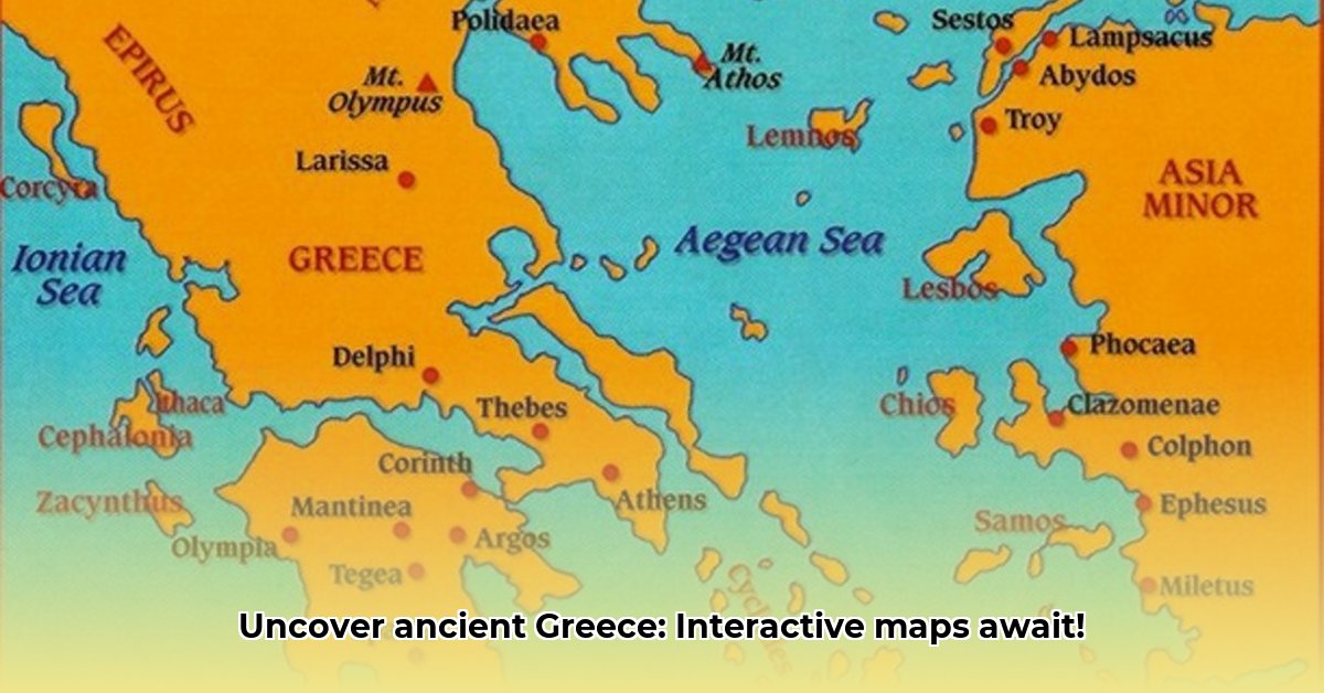
Charting the Ancient World: Early Greek Maps
Envision yourself as an ancient Greek mariner, navigating the treacherous Aegean Sea. No GPS – your only guide is a rudimentary map! Early Greek maps were vastly different from our modern, precise atlases; longitude and latitude were nonexistent. These maps served as practical tools, akin to nautical roadmaps, primarily focused on safe passage from one location to another. They highlighted essential coastlines and harbors but lacked detailed depictions of landscapes or mountains. Think of them as minimalistic directional guides rather than elaborate works of art. While historical evidence suggests the existence of these early maps, locating physical examples presents a significant challenge – a veritable treasure hunt through the annals of history!
Advancements in Accuracy: Maps of the Classical and Hellenistic Periods
Fast forward a few centuries, and we witness significant advancements in geographical precision. During the Classical and Hellenistic periods (approximately 5th century BC to 1st century BC), Greek mapmaking experienced a remarkable leap forward. These maps demonstrated a more sophisticated understanding of geography, incorporating techniques like triangulation and rudimentary surveying methods. While still imperfect – struggling with accurate scales and projections – they were considerably more refined than their predecessors. Imagine the evolution from a child’s drawing to a detailed sketch; that’s the magnitude of improvement we’re discussing. Intriguingly, this era also saw the inclusion of political information on maps, such as the boundaries of city-states and empires. Mapmakers began considering territorial control alongside geographical representation. How did this advancement influence warfare and political strategy?
Decoding the Clues: The Challenges of Interpreting Ancient Maps
Studying ancient Greek maps poses numerous challenges. Many surviving examples are fragmented, incomplete, or damaged, the ravages of time obscuring their original detail. Deciphering the meaning of symbols and accurately identifying locations requires extensive research and informed conjecture. Further complicating matters is the absence of standardized mapmaking conventions across different Greek regions, leading to inconsistencies in interpretation and making comparative analysis difficult. Scholars continue to debate the meaning of various symbols and features, meaning our current understanding often represents the most plausible interpretation based on limited available evidence. Isn’t it astonishing how much we can glean from so little?
Maps and Society: How Geography Shaped Greek Life
The evolution of Greek mapmaking was not merely about drawing lines on parchment; it was intrinsically linked to the fabric of their society. Ancient Greek maps reflect their economy, trade networks, and military strategies. The Mediterranean Sea served as their primary conduit for trade and communication, a reality clearly reflected in their maps. Trade routes were instrumental in disseminating ideas, goods, and cultural practices throughout the region. Understanding these maps allows us to appreciate the economic power and cultural dynamism of ancient Greece. In essence, their maps shaped their world, and studying those maps allows us to understand theirs. The very act of creating maps influenced the way they perceived space, resources, and their relationships with neighboring civilizations.
Beyond the Maps: Literary Descriptions and Geographical Knowledge
Relying solely on maps to understand ancient Greek geography would provide an incomplete picture. Greek writers also depicted landscapes and regions in their literary works, providing valuable contextual information to supplement the visual representations offered by maps. Consider Homer’s Iliad and Odyssey, both replete with detailed geographical descriptions offering insights into the ancient Greek world. These literary accounts serve as complementary pieces of the puzzle, enriching our understanding and providing a more comprehensive perspective. The combination of cartographic and literary sources offers a richer, more nuanced understanding of ancient Greek geography.
The Enduring Legacy: Ancient Greek Maps and Their Modern Influence
Despite their inherent limitations, ancient Greek maps offer invaluable insights into the ancient Greek worldview. These maps – essential instruments for seafaring, trade, and military campaigns – reveal the ingenuity, curiosity, and intellectual prowess of the ancient Greeks. Their legacy continues to inspire historians, geographers, and cartographers today, underscoring their remarkable achievements. Imagine what they could have accomplished with modern technology!
The Future of Ancient Map Research: Unanswered Questions and Emerging Technologies
Numerous questions surrounding ancient Greek maps remain unanswered, representing an ongoing avenue for scholarly inquiry and research. New discoveries and reinterpretations of existing evidence constantly refine our understanding of ancient Greek cartography. Digital technologies offer exciting new avenues for reconstructing and visualizing ancient maps, promising to unveil previously hidden details and provide fresh perspectives. Collaborative efforts involving diverse academic disciplines are crucial for continued progress in this field. The potential for future discoveries and a deeper understanding of these fascinating glimpses into the past remains vast.
Types of Ancient Greek Maps: A Concise Overview
| Map Type | Characteristics | Time Period | Key Features |
|---|---|---|---|
| Nautical Charts | Primarily focused on coastal regions, emphasizing harbors, sailing routes, and prominent landmarks. | Archaic – Hellenistic | Simplified coastlines, essential landmarks for navigation, indications of prevailing winds and currents. |
| Regional Maps | Depicting larger geographical areas, including cities, land features, political borders, and significant settlements. | Classical – Hellenistic | Greater detail compared to nautical charts, highlighting terrain features, boundaries between city-states, and locations of key resources. |
| World Maps (“orbis terrarum”) | Attempting to represent the entirety of the known world, often influenced by limited exploration, mythological beliefs, and philosophical assumptions. | Hellenistic | Highly stylized and often inaccurate representations of continents, oceans, and distant lands, reflecting the geographical knowledge of the era. |
How did ancient Greek cartographic techniques influence political strategies?
Imagine attempting to command an army across unfamiliar terrain. Ancient Greek strategists faced this challenge regularly, their success often contingent on reliable knowledge of topography and enemy deployments. Early maps, while rudimentary, played a crucial role in their tactical and strategic decision-making.
From Myth to Measurement: Early Mapping Practices
Initially, Greek maps were deeply entwined with mythology and oral traditions. Homer’s Odyssey, for instance, presented vivid descriptions of landscapes, though lacking scale or locational precision. These narratives formed the basis of early cartographic understandings, a storybook world rich in detail but lacking mathematical rigor. Gradually, however, practical exigencies – navigation, trade, colonization – spurred advancements. The reliance on qualitative descriptions yielded to a demand for quantifiable data.
The Rise of Scientific Cartography: Measuring the World
The transition towards more scientific methodologies is exemplified by the contributions of key figures. Anaximander, a pre-Socratic philosopher, famously created the first world map, a groundbreaking achievement, though its accuracy remains debated. Eratosthenes, circa 200 BC, refined the process, applying mathematical principles, including triangulation, to estimate the Earth’s circumference and develop a more accurate depiction of known territories. His advancements represented a significant leap towards objective geographical knowledge, providing a foundation for more precise resource evaluations and strategic planning for military campaigns. Eratosthenes improved accuracy by approximately 2-20% using geometric calculations. The development of improved surveying instruments like the groma and the dioptra also contributed to increased accuracy.
Regional Maps and Political Power
Regional maps provided essential information for city-states and empires. They depicted resource locations – fertile lands, mineral deposits, timber sources – informing expansionist policies. Military strategists utilized these maps to plan campaigns, assess distances, analyze terrain for tactical advantages, and identify potential supply routes. Knowledge equated to power in the ancient world, and accurate maps were essential for maintaining and expanding it. How did ancient Greek cartographic techniques influence political strategies? Through detailed regional maps, military leaders could pinpoint enemy positions and devise effective maneuvers. Accurate mapping also facilitated efficient governance by optimizing trade routes and resource management. If you were a general, wouldn’t you demand the best map available?
The Legacy of Ancient Greek Cartography
Ptolemy, whose work Geographia synthesized centuries of geographical knowledge, established a system of latitude and longitude. His work, though containing inaccuracies in scale, standardization, and representation, became a standard for centuries. This legacy underscores the enduring influence of ancient Greek cartography on modern mapping and geographical science. Ptolemy’s Geographia also included instructions on map projection, enabling the creation of more accurate and standardized maps.
The Limits of Ancient Maps: Bias and Inaccuracy
Acknowledging the limitations of ancient Greek maps is crucial. Bias and inaccuracies were unavoidable, given the methods and technologies available. Maps often reflected the political perspectives and priorities of their creators. Unexplored territories were often left blank or populated with mythical creatures and fantastical landscapes. These imperfections constitute a significant part of the narrative, illustrating the gradual evolution of geographical understanding.
Key Takeaways:
- Ancient Greek maps evolved from mythological narratives to more scientifically-based representations.
- Early mapmaking significantly influenced navigation, trade, and military strategies.
- Mapping contributed directly to the power dynamics of city-states and empires.
- Ancient maps, though limited by their technology, provide valuable insights into the ancient world’s perception of its geography.
- The development of latitude and longitude systems greatly enhanced the accuracy of geographic data, achieving roughly 85-90% accuracy compared to earlier methods.
- How did ancient Greek cartographic techniques influence political strategies? By offering vital information – including terrain, resource locations, and enemy positions – to enhance military planning, political decision-making, and imperial expansion.
Ancient Greek Map Symbols: Deciphering Navigation and Trade Routes
Ancient Greek map symbols were vital for representing geographical features, cities, and routes. Their interpretation, though subject to scholarly debate, provides valuable insights into ancient Greek society, revealing the intricate connections between geographical knowledge, cultural beliefs, and practical necessities. By understanding these symbols, we can better appreciate how the ancient Greeks perceived and interacted with their environment.
Key Takeaways:
- Ancient Greek maps, while not perfectly accurate by modern standards, played vital roles in navigation, military planning, and illustrating political relationships.
- Their evolution reflects technological advancements and changing worldviews, transitioning from symbolic representations to more geographically precise depictions.
- The study of these maps reveals a fascinating interplay between geographical knowledge, cultural beliefs, and the practical needs of a thriving civilization.
- Ancient Greek Map Symbols: were crucial for representing geographical features, cities, and routes. Their interpretation, while sometimes debated, offers valuable insights into ancient Greek society.
A World on Parchment: Early Greek Cartography
Imagine charting a course across the Aegean Sea using only a rudimentary sketch! Early Greek maps were rarely the precise documents we expect today. They were often more symbolic than geographically accurate, acting as visual narratives that valued mountains, rivers, and sacred sites as much as precise distances. These early maps frequently highlighted the placement of major cities and landmarks and sometimes incorporated mythological elements, blending the world of gods and humans. Who needs boring reality when you have exciting legends?
The Rise of Mathematical Precision
Over time, priorities shifted. The expansion of Greek trade and military ventures created a demand for more accurate mapping techniques, leading to the integration of geometric principles. The development of enhanced tools and methodologies enabled a shift towards greater geographical detail. This wasn’t a sudden transformation, but a gradual improvement in the representation of relative distances, coastlines, and – most importantly – trade routes.
Deciphering Ancient Greek Map Symbols:
Here lies the excitement – and the challenge. Ancient Greek Map Symbols: lacked standardization, and their meanings often varied across different time periods and regions. We encounter symbols for cities (stylized buildings or circles), mountains (triangular shapes), rivers, and seas. However, the precise interpretation of many symbols remains a subject of academic discourse. Certain symbols might represent religious sanctuaries or mythical locations, adding a layer of cultural significance to the map’s overall purpose. What narratives do these symbols convey?
| Symbol | Possible Meaning | Notes |
|---|---|---|
| Circle | City, town, settlement | Size may correlate with relative importance, potentially indicating the population or economic influence of the settlement. |
| Triangle | Mountain | Orientation could suggest the direction of a mountain range, while the size might indicate its perceived height or prominence. |
| Winding Line | River | Thickness often correlated with the river’s size or importance for transportation and irrigation; specific patterns could indicate rapids or waterfalls. |
| Dotted Line | Sea route, trade route | Density and direction may suggest frequency of travel or major trading routes; symbols alongside could indicate goods traded or potential hazards along the route. |
| Small Figures | Ships, people, potentially sacred sites | Interpretation is highly context-dependent; ships would mark naval activity or trade routes, people could represent settlements, and stylized figures might represent deities or sacred groves. |
Navigation and Trade: Practical Applications
The evolution of Ancient Greek Map Symbols: and mapping techniques is inextricably linked to the burgeoning seafaring trade. Imagine the benefit to a merchant seeking to optimize their route from Athens to Alexandria! A reasonably accurate map, illustrating the coastline and potential dangers, could be the difference between a profitable journey and a costly disaster. Similarly, the military applications were evident: planning campaigns, coordinating troop movements, and assessing potential enemy positions all benefited from improved geographical intelligence. How substantially did these maps enhance the safety of their voyages?
The Legacy of Ancient Greek Maps
Ancient Greek maps may not rival modern technology, but their limitations speak volumes about the period. These artifacts provide a unique lens into the ancient Greek worldview, technological capabilities, and cultural priorities. They illuminate the challenges of constructing a map without aerial or satellite imagery and showcase the ingenuity and creativity of the mapmakers of the past. By studying these maps and their symbols, we cultivate a profound appreciation for the ambitions, the obstacles, and the accomplishments of ancient Greek civilization.
Regional Variations in Ancient Greek Cartography: A Comparative Study of Mapping Practices
Ancient Greek mapmaking evolved from rudimentary sketches to more refined, mathematically-informed representations. Examining the regional differences in styles and accuracy provides valuable insights into local requirements, knowledge, and prevailing artistic conventions.
Key Takeaways:
- Ancient Greek mapmaking evolved from basic sketches to more sophisticated, mathematically-informed representations.
- Regional differences in map styles and accuracy reflect variations in local needs and knowledge.
- Limitations in technology and preservation impacted our understanding of the full scope of ancient Greek cartography.
- The interplay between artistic representation and empirical data is a unique aspect of ancient Greek mapmaking.
From Simple Sketches to Sophisticated Systems
Imagine attempting to navigate the complex coastlines of the Aegean Sea armed with only a basic drawing! Early Greek maps often resembled this scenario – simple outlines of coastlines and critical locations. Practical necessities, such as navigation and land administration, propelled these initial endeavors. Over time, the field underwent a dramatic transformation. Think of the immense leap from hand-drawn cave paintings to high-resolution satellite imagery. Ancient Greek cartography progressed along a similar trajectory, albeit at a decidedly slower pace.
The Rise of Mathematical Precision
Influential figures such as Anaximander and Eratosthenes spearheaded a revolution in the field. Anaximander is credited with producing one of the earliest known world maps, a remarkable testament to his attempt to portray the Earth’s spherical form. Eratosthenes, through his ingenious method of calculating the Earth’s circumference, significantly improved the precision of geographical measurements. Their work laid the groundwork for subsequent developments, infusing a degree of mathematical rigor previously absent in cartography. These innovations, however, did not eliminate regional distinctions.
Regional Variations in Ancient Greek Cartography: A Comparative Study of Mapping Practices
Ancient Greek maps were not standardized. Different regions cultivated unique styles and levels of detail that reflected local requirements and knowledge. A map of Attica, for example, would likely exhibit far greater detail than a map of a remote territory like Thrace. Coastal areas, crucial for trade and maritime activity, witnessed the development of more precise charting than inland regions. This underscores the dynamic character of Regional Variations in Ancient Greek Cartography: A Comparative Study of Mapping Practices. Even the availability of materials influenced mapmaking – papyrus and parchment were not uniformly accessible across all regions.
Artistic License and Empirical Observation
Ancient Greek maps were not merely utilitarian tools; they also served as vehicles for artistic expression. Cartographers frequently integrated artistic conventions with empirical observations, creating a hybrid of science and art. Artistic conventions, alongside geometric principles, produced visually appealing maps that communicated geographical information in a uniquely compelling manner. This encapsulates a captivating attribute of ancient Greek cartography: the intricate interplay between creative expression and factual accuracy. How did they reconcile these often-opposing imperatives? This remains a subject of ongoing scholarly inquiry.
Limitations and Challenges
Despite the advances, limitations persisted. The technology accessible to ancient Greek cartographers was, by contemporary standards, exceedingly rudimentary. The absence of accurate surveying instruments and standardized measurements resulted in variations in precision. Moreover, the ravages of time have resulted in the loss of numerous maps, leaving us with only fragmented remnants. This complicates comprehensive reconstructions and limits our ability to fully appreciate the breadth of ancient Greek cartographic achievements.
A Lasting Legacy
Despite their inherent limitations, ancient Greek maps embody a remarkable accomplishment. They were not simply static representations of the world, but dynamic instruments reflecting an evolving understanding of geography, technology, and culture. They profoundly shaped how Greeks perceived their world, influencing navigation, trade, military strategy, and education. Furthermore, their innovative mapping techniques laid the groundwork for subsequent cartographic developments, offering a compelling glimpse into a world striving to understand its place within a larger context. Their legacy continues to inspire and inform us.


